Encino, Los Angeles
The name Encino is the misspelling in masculine of Encina, the Spanish word for "holm oak” (Quercus ilex).
"[2][3] In 1769, the Spanish Portolá expedition, first Europeans to see inland areas of California, traveled north through Sepulveda Pass into the San Fernando Valley on August 5 and stayed two nights at the Tongva village of Siutcanga ("the place of the oaks") near what is now Los Encinos State Historic Park.
[5] The 2000 U.S. census counted 41,905 residents in the 9.5-square-mile (25 km2) Encino neighborhood — 4,411 inhabitants per square mile (1,703/km2), among the lowest population densities for the city but average for the county.
Iran (30.1%) and Russia (6.4%) were the most common places of birth for the 32.8% of the residents who were born abroad—an average percentage for Los Angeles.
[6] Encino is situated in the central portion of the southern San Fernando Valley and on the north slope of the Santa Monica Mountains.
It is flanked on the north by Reseda, Lake Balboa, and the Sepulveda Basin, on the east by Sherman Oaks, on the south by Brentwood, and on the west by Tarzana.
[15] By 2000, forty-six percent of Encino residents aged 25 and older had earned a four-year degree, a high percentage for both the city and the county.
[24] The park includes the original nine-room de la Ossa Adobe, the Garnier Building, a blacksmith shop, a pond, and a natural spring.
[25] The Sepulveda Dam Recreation Area, located in Encino,[26] includes the Woodley Worel/Magnus Cricket Complex.
[31] The Sepulveda Basin Recreation Area[116][117] is a large area with multiple golf courses, tennis courts, soccer fields, baseball diamonds, bike paths, and a lake bordered by about 2,000 Pink Cloud cherry trees that blossom in the spring.
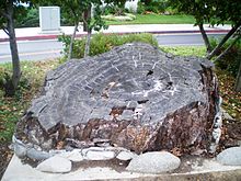
Today there is a monument to the tree at the corner of Ventura Boulevard and Louise Avenue where the Encino Oak once stood.