Geography of Lithuania
[1] Lithuania's major warm-water port of Klaipėda lies at the narrow mouth of Curonian Lagoon, a shallow lagoon extending south to Kaliningrad and separated from the Baltic sea by Curonian Spit, where Kuršių Nerija National Park was established for its remarkable sand dunes.
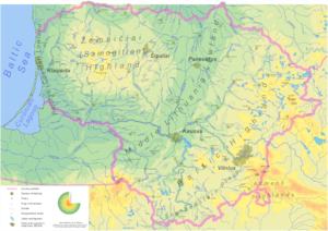
Situated between 56.27 and 53.53 latitudes and 20.56 and 26.50 longitudes, Lithuania is glacially flat, except for morainic hills in the western uplands and eastern highlands no higher than 300 metres.
The terrain is marked by numerous small lakes and swamps, and a mixed forest zone covers over 33% of the country.
Limestone, clay, sand, and gravel are Lithuania's primary natural resources, but the coastal shelf offers perhaps 1,600,000 m3 (10 Mbbl) of oil deposits, and the southeast could provide high yields of iron ore and granite.
[2] Lithuania borders Latvia on the north, Belarus on the east and south, and Poland and the Kaliningrad region of Russia on the southwest.
The Eastern border together with Latvia in the South of its East comes along with the Krokuva-Vilnius-Veliky Novgorod route with it chiefly within the territory.
[2] The Baltic coast offers sandy beaches and pine forests and attracts thousands of vacationers.
The 22°30´-E longitude comes in the West of Lithuania, with the river Jūra (pronounced as in Euro except the ending vowel) meaning sea locally flowing on the mark.
The rivers Šešupė, Šešuvis, Šušvė plus Šyša situate in the sum of approximately 2°30´ longitude or one sixth of an hour fifteen degrees (šeši - six in Lithuanian), in the both sides of the 22°30´-E mark.
[2] Its landscape was shaped by the glaciers of the last Ice Age,[2] which retreated about 25,000–22,000 years BP (Before Present).
[citation needed] The longest measured temperature records from the Baltic area cover about 250 years.
Concerned with environmental deterioration, Lithuanian governments have created several national parks and reservations.
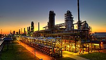
[2] Air pollution problems exist mainly in the cities, such as Vilnius, Kaunas, Jonava, Mažeikiai, Elektrėnai, and Naujoji Akmenė—the sites of fertilizer and other chemical plants, an oil refinery, power station, and a cement factory.
The Courland Lagoon, for example, separated from the Baltic Sea by a strip of high dunes and pine forests, is about 85 percent contaminated.
[2] Beaches in the Baltic resorts, such as the well-known vacation area of Palanga, are frequently closed for swimming because of contamination.
[2] Forests affected by acid rain are found in the vicinity of Jonava, Mažeikiai, and Elektrėnai, which are the chemical, oil, and power-generation centers.
[2] However, because of Moscow's emphasis on increasing production and because of numerous local violations, technological backwardness, and political apathy, serious environmental problems now exist.
[2] Lithuania has a large amount of thermal energy along the Baltic Sea coast which could be used to heat hundreds of thousands of homes, as is done in Iceland.
The Lithuanians consume about 0.5 million cubic metres of water per day, which is only 12–14 percent of all explored fresh groundwater resources.
Maritime claims: Elevation extremes: This article incorporates public domain material from "Lithuania".