Climate of Norway
This is mainly due to the North Atlantic Current with its extension, the Norwegian Current, raising the air temperature;[1] the prevailing southwesterlies bringing mild air onshore; and the general southwest–northeast orientation of the coast, which allows the westerlies to penetrate into the Arctic.
Some areas of Vestlandet and southern Nordland are among Europe's wettest, due to orographic lift, particularly where the westerlies are first intercepted by high mountains.
Lurøy Municipality at the Arctic Circle gets 3,066 mm (120.7 in) annually, a remarkable amount for a polar location.
Precipitation is heaviest in late autumn and winter along the coast, while April to June is the driest.
Finnmarksvidda has the coldest winters in mainland Norway, but inland areas much further south can also experience severe cold.
Inland valleys and the innermost fjord areas have less wind and see the warmest summer days.
The warmest night recorded in Norway was July 29, 2019 at Sømna-Kvaløyfjellet (302 m) in Sømn Municipalitya near Brønnøysund with overnight low 26.1 °C (79.0 °F).
Areas in Norway located north of the Arctic Circle have extreme darkness in winter, which increases with latitude.
At Longyearbyen on the Svalbard islands in the extreme north, the upper part of the sun's disc is above the horizon from 9 April to 23 August, and winter darkness lasts from 27 October to 14 February.
As the country is very elongated, this is at odds with the local daylight hours in the eastern and western parts.
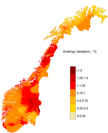
All regions and seasons of Norway are expected to become warmer and wetter due to climate change.
On a per-capita basis, Norway is the world's largest producer, and exporter, of oil and natural gas outside the Middle East.
Warmer temperatures in Norway are causing permafrost and glaciers to retreat, and leading to shifts in precipitation patterns.
Biodiversity and forested areas are experiencing shifts due to the phenomenon, with significant implications for the agriculture and economy of the country.