Erratic Rock State Natural Site
Purchased from the Duerst and Ramsby families in 1956, the park was originally named the Erratic Rock Wayside.
The park received a new historical marker along the road in June 2005 in a ceremony featuring state senator Gary George.
[4] Located off Oregon 18, Erratic Rock State Natural Site lies midway between Sheridan to the west and McMinnville to the east.
[5][6] The pre-historic Missoula floods began in western Montana fifteen to twenty-thousand years ago.
[7] Many rocks were transported down the Columbia encased in icebergs and deposited from Montana through Idaho, Washington, and Oregon when the flood waters receded and the ice melted.
Along with the flora and fauna indigenous to Oregon in general, the ones that are more specific to Yamhill county are categorized as wildlife species of the northwest region.
Some of the plants and animals listed on the endangered species are: the marbled murrelet (Brachyramphus marmoratus), the Northern Spotted Owl (Strix occidentalis caurina).
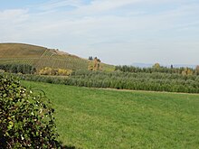
[17] There is a 0.2 mile (320 m) easy hike along a paved trail to the top of the hill past a vineyard and orchard.
In addition to the boulder, the hilltop features views of the Oregon Coast Range and the valley, including vineyards and farms.
[6][8][26] There is a 0.2-mile (320 m) hike along a paved trail to the top of the hill past a vineyard and orchard that provides bird watching opportunities.