Esopus Creek
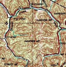
[11] Bending to the west northwest, the Esopus forms part of the boundary of the Big Indian Wilderness Area to its south[12] as it receives Giant Ledge Stream from the north, draining the peak of that name and Panther Mountain, the former meteor crater[13] whose walls determine the creek's upper course.
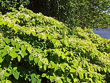
Another half-mile further west, the Esopus receives its first left tributary, Hanging Birds Nest Brook, which drains the north face of Spruce and Hemlock mountains to the south.
At the mouth of the hollow, in the small hamlet of Big Indian, 8.5 miles (13.7 km) from its source,[5]: 110 the Esopus turns east and crosses under New York State Route 28, which it closely parallels all the way to Ashokan Reservoir, at 1,200 feet (370 m) in elevation.
Another thousand feet downstream, Fire House Road (County Route 47) crosses, after which the Esopus turns sharply to the north, then northeast at a large gravel bar, for its next mile.
[36] Over the next 1.2 miles (1.9 km) the Esopus bends back and forth through similar terrain, paralleling New York State Route 213 for a thousand feet (305 m) below a steep bluff, to where its valley widens and cultivated fields become dominant in the surrounding landscape.
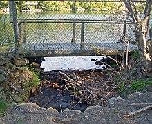
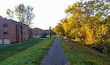
[48] After a half-mile with an apartment complex and strip mall on the south side and woodlands on the north of the 180-foot-wide (55 m) channel,[38] Tannery Brook empties into the Esopus from a buried culvert just below where Route 28, now concurrent with Interstate 587, crosses the creek[47] for the last time.
[38] A mile north of the Saw Kill, the Esopus bends northeast again and Leggs Mill Road (County Route 31) crosses as the stream descends slightly over a weir and some exposed bedrock.
Downstream of that point, its flood plain becomes heavily farmed, with 2,000 acres (810 ha) of worked agricultural land, mostly cornfields, abutting the stream between there and the Leggs Mills Road bridge at Lake Katrine.
[13] The Esopus's upper course was set 375 million years ago in the Devonian period, when the Catskills were still a river delta of low sedimentary beaches and the shallow channels between them to a large inland sea that corresponds to the location today of the Allegheny Plateau.
A meteor impact during this time left an approximately 6 miles (9.7 km) wide crater whose walls correspond to the courses of the upper Esopus and Woodland Creek today.
Geologist Yngvar Isachsen of the New York State Geological Survey discovered the traces of the meteor impact, including a higher fault density in the bedrock on the Esopus, in the late 20th century.
As with many other streams in Ulster County, the Native Americans used the flat flood plains of the lower Esopus for cornfields, and there are accounts of the area around Olive, today inundated by the reservoir, planted as an apple orchard.
[67]: 33–39 In 1704 a group of farmers in Hurley petitioned the colonial governor, Viscount Cornbury, for some of the undeveloped land to their west along the creek to use as common pasture and firewood, since they were getting squeezed by Kingston to their east and Marbletown to the south.
The Hardenbugh Patent, as it became known, is the source of many of the land titles in the Catskills today, although its legitimacy was contested from the beginning, a dispute which continued until after the Revolution, aggravated by inadequate surveys of the region.
Winter, was an avid practitioner and promoter of the new sport of fly fishing, which he believed had therapeutic effects, making "a person for a time forget he ever had any care, business, or anxiety.
His visit attracted much attention locally, with residents lining the Ulster and Delaware's rails to see him and huge crowds waiting to shake his hand at stations[5]: 132–33 In 1861 the city of Kingston had considered buying the land around Bishop's Falls near Ashokan to dam and use as a reservoir.
The creek's soft water was now held to be its chief virtue, as it would among other things save the city's residents almost a half million dollars a year on soap, by a 1903 report Freeman contributed to.
[70]: 150 Two years later the state allowed the city to create its own water supply commission and granted it the exclusive right to acquire land in the Esopus and Schoharie watersheds and construct two reservoirs.
[67]: 591 [e] Residents in the Esopus valley attempted to block the project, objecting to the dislocation the proposed reservoir would require, forcing out the population of seven hamlets and relocating the Ulster and Delaware.
During the 1974 fishing season, two trout kills along the Esopus that the New York State Department of Environmental Conservation (DEC) attributed to the Portal discharges led to anger at the city and threats of lawsuits.
[91]: 20 To avoid a federal requirement that it build a water filtration plant that would cost several billion dollars,[i] in 1990 the city instituted stricter rules for the use of its lands in its watersheds,[j] regulations that adversely affected the local economies.
In the hundred days following the storm and its successor, 40 billion US gallons (150 million cubic metres) of dark brown muddy water was channeled down the creek in order to clear the reservoir itself.
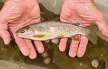
[67]: 397 Theodore Gordon, considered the father of American dry-fly fishing, did most of his angling in the Beaver Kill, Willowemoc Creek, the Neversink River and other streams of Sullivan County, south of the Esopus watershed.
[136] Most of the lowermost 12.7 miles (20.4 km) of the stream, from Cantine Dam in Saugerties to the Tannery Brook confluence near Kingston,[137] is rated Class B, suitable for primary and secondary contact recreation and fishing.
[145] In 2011 a study of the lower Esopus found no significant effect on benthic macroinvertebrates (BMI) at several points in the stream over the previous four years, the period when complaints about the turbidity caused by the reservoir releases began.
[110] Bedrock of the upper Esopus is generally sedimentary rock of the middle to late Devonian period, deposited when today's Catskills were a river delta and alluvial plain 360-390 million years ago.
[156]: C7–C8 Below the Ashokan Reservoir, the Catskill sediments continue to underlie the lower Esopus,[35]: 8–9 this time in the form of the region's lowest and oldest layer, the Givetian Plattekill Formation.
Management of the upper stream is more hands-on due to its major role in New York City's water supply system, its importance as a recreational resource and its location amid the Forest Preserve.
New York's Department of Environmental Conservation (DEC) says it has found no sign of that, but in 2000 the Catskills chapter of Trout Unlimited, Riverkeeper and some other groups sued the city, arguing the Portal releases into the creek violated the federal Clean Water Act.
[126][160] Research done by the USGS's New York Water Science Center in 2015 found that D. geminata had not appeared to impair the creek's fishery and aquatic life in general significantly, based on periphyton samples taken from 6–20 locations along the upper Esopus on five occasions during 2009–10.