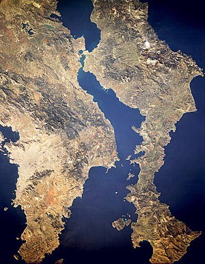
Euripus Strait
Water flow peaks at about 12 kilometres per hour (7.5 mph; 6.5 kn), either northwards or southwards, and lesser vessels are often incapable of sailing against it.
[2] From Ancient Greek εὔριπος (eúrīpos, "any strait or narrow sea, where the flux and reflux is violent");[3] from εὖ (eû, "well") + ῥιπή (rhipḗ, “swing or force with which anything is thrown”), from ῥίπτω (rhíptō, "to throw").
[5] Herodotus mentions the strait during his description of the Battle of Artemisium (480 BC), with the account implying that it was navigable by large fleets of triremes.
[6] Diodorus Siculus reports that in 411 BC the Euboeans closed the strait by mostly rebuilding the dike, with the goal of making themselves part of Boeotia, therefore not an island subject to Athenian hegemony.
[7] Diodorus states that gaps had to be left in the dike to allow the Euripus tides to flow through; the narrowness of the remaining passage made the current much more intense.
Strabo wrote that at an unspecified later date the strait was crossed by a bridge two plethra long[8] (approximately 50 m (160 ft), which is probably an exaggeration[citation needed]).
In 1408, the formation of a reef under the bridge severely affected shipping (http://www.archiviodistatovenezia.it/divenire/collezioni.htm Archived 2016-01-27 at the Wayback Machine Senato, Deliberazioni, Misti.
48,43v) and in 1439 there was concern over the tendency of the current to erode the surroundings of the pilings that supported the bridge (http://www.archiviodistatovenezia.it/divenire/collezioni.htm Archived 2016-01-27 at the Wayback Machine Senato, Deliberazioni, Misti.