Eyewall replacement cycle
[3] The discovery of this process was partially responsible for the end of the U.S. government's hurricane modification experiment Project Stormfury.
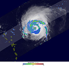
[10] Hurricane Beulah in 1967 was the first tropical cyclone to have its eyewall replacement cycle observed from beginning to end.
Beulah was observed from the Puerto Rico land-based radar for 34 hours during which time a double eyewall formed and dissipated.
It was noted that Beulah reached maximum intensity immediately prior to undergoing the eyewall replacement cycle, and that it was "probably more than a coincidence.
"[11] Previous eyewall replacement cycles had been observed to decrease the intensity of the storm,[9] but at this time the dynamics of why it occurred was not known.
[12] By early 1960, the working theory was that the eyewall of a hurricane was inertially unstable and that the clouds had a large amount of supercooled water.
The expansion of the eyewall would be accompanied with a decrease in the maximum wind speed through conservation of angular momentum.
[12] Project Stormfury was an attempt to weaken tropical cyclones by flying aircraft into them and seeding with silver iodide.
[13] The hypothesis was that the silver iodide would cause supercooled water in the storm to freeze, disrupting the inner structure of the hurricane.
The observational data and storm lifecycle research generated by Stormfury helped improve meteorologists' ability to forecast the movement and intensity of future hurricanes.
Kossin et al. specified that the outer ring had to be visibly separated from the inner eye with at least 75% closed with a moat region clear of clouds.
[2][14] Eyewall replacement cycles, such as occurred in Rita as it approached the Gulf Coast of the United States, can greatly increase the size of tropical cyclones while simultaneously decreasing their strength.
The authors note that because the reconnaissance aircraft were not specifically looking for double eyewall features, these numbers are likely underestimates.
There were no cases of double eyewalls where the maximum sustained wind was less than 45 m/s or the minimum pressure was higher than 970 hPa.
The majority of Western and Central Pacific typhoons that experience double eyewalls do so in the vicinity of Guam.
Since the advent of reconnaissance airplanes and microwave satellite data, it has been observed that over half of all major tropical cyclones develop at least one secondary eyewall.
[19] Willoughby suggested that a resonance between the inertial period and asymmetric friction may be the cause of secondary eyewalls.
[20] Later modeling studies and observations have shown that outer eyewalls may develop in areas uninfluenced by land processes.
[21] Rapid deepening of the tropical low in connection with synoptic scale forcing has been observed in multiple storms,[22] but has been shown to not be a necessary condition for the formation of a secondary eyewall.
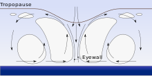
[14][25] In a fluid system, β (beta) is the spatial, usually horizontal, change in the environmental vertical vorticity.
If areas of high CAPE exist in the β-skirt, the deep convection that forms would act as a source of vorticity and turbulence kinetic energy.
Once this low-level jet forms, a positive feedback cycle such as WISHE can amplify the initial perturbations into a secondary eyewall.
In the moat region between the inner and outer eyewall, observations by dropsondes have shown high temperatures and dewpoint depressions.
[28] Once the inner eyewall dissipates, the storm weakens: the central pressure increases and the maximum sustained windspeed decreases.
Typhoon Winnie (1997) developed an outer eyewall with a diameter of 200 nautical miles (370 km) that did not dissipate until it reached the shoreline.
The simulations show that the major rainbands will grow such that the arms will overlap, and then it spirals into itself to form a concentric eyewall.