Fairfax Line
Lewis's journal of the expedition provides a vivid account of the extraordinarily difficult terrain of the pre-settlement Allegheny Mountains.
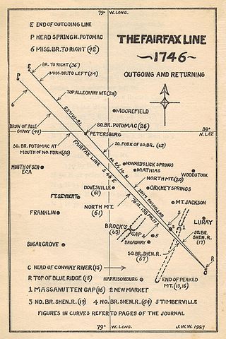
The Fairfax Line runs in a northwesterly direction for about 77 miles (124 km) through exceptionally rugged terrain: from the crest of the Blue Ridge Mountains in Virginia, to that of the Allegheny Mountains in West Virginia, traversing the headwaters of the Shenandoah River along the way.
The source is on the eastern slope of the Blue Ridge Mountains, near mile marker 55 on the Skyline Drive (approximately 30 miles (48 km) north of Charlottesville, Virginia), where the borders of the Virginia counties of Page, Madison and Greene meet.
The northwestern terminus of the line — at the Fairfax Stone — is the source of the North Branch of the Potomac River.
The stone's location is on the borders of the present West Virginia counties of Preston, Tucker and Grant, and one mile south of the southwestern tip of Maryland Panhandle.