Falkner's Circle
The ring was part of a tradition of stone circle construction that spread throughout much of Britain, Ireland, and Brittany during the Late Neolithic and Early Bronze Age, over a period between 3300 and 900 BCE.
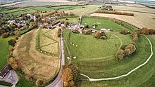
Positioned in a dry valley, the circle was erected on the southern end of a field that contained a range of natural sarsens.
The site had previously seen human activity in the Mesolithic period and may have been symbolically meaningful for local communities for a long time before the circle was created.
The ring was located close to other Late Neolithic and Early Bronze Age monuments, such as the West Kennet Avenue and Avebury stone circle, although its precise relationship to these is unclear.
Archaeological evidence indicates that in the Iron Age, a hearth was placed on the site, and in the post-medieval period a number of the stones were toppled and destroyed through burning.
Most of the stones in the circle were lying prone on the ground by the seventeenth century, which might explain why it was left undiscovered by antiquarians exploring the area in that period, like John Aubrey and William Stukeley.
[4] By 3000 BCE, the long barrows, causewayed enclosures, and cursuses that had predominated in the Early Neolithic were no longer built, and had been replaced by circular monuments of various kinds.
[1] Archaeologists initially suggested that a fifth example could be seen at Langdean Bottom near the village of West Overton, although further investigation has reinterpreted this as evidence for a late prehistoric hut circle or a medieval feature.
[1][11] Burl suggested that these smaller circles related to Avebury in a manner akin to "village churches within the diocese of a cathedral".
[15] Because of this location on the edge of the sarsen scatter, the archaeologist Mark Gillings and his team proposed that the circle's builders may have understood this as a "liminal" space that was worthy of monumentalisation.
[15] Compared to many other built structures in the area, such as the Avebury henge, Silbury Hill, and West Kennet Avenue, it is diminutive.
[19] The 2002 excavation at the site discovered five pits cut into the chalky gravel, which lay on an arc with a diameter of about 44m, spaced between 13 and 17m apart.
The majority of this was flake debitage of Late Neolithic or Early Bronze Age character, and suggested that flint knapping had taken place at that location.
[22] A spread of fire-reddened clay and charcoal flecking, covering an area of circa 10m by 4m, was interpreted as having been produced in the post-medieval period during the burning and destruction of some of the stones.
[20] Falkner's Circle was not described by the various seventeenth- and eighteenth-century antiquarians who explored and recorded the prehistoric monuments around Avebury, such as John Aubrey, Stukeley, and Colt Hoare.
This was likely because the circle was at this point largely hidden, with all but one of the stones lying prone and the standing example concealed within the adjacent hedgerow.
[26] In August and September 2002, the archaeologists Mark Gillings, Joshua Pollard, David Wheatley, and Rick Peterson led a four-week archaeological investigation of the circle, as part of which they carried out both geophysical examination and excavation.