Feldberg (Black Forest)
From the Seebuck the Feldberg drops steeply away to the northeast into the Feldsee, a lake of glacial origin at about 1,000 metres (3,300 ft) altitude.
The main car park below the Seebuck can be reached from the B317 (federal highway) running from Titisee to Lörrach (near Basel) over the Feldberg Pass.
The numerous point-to-point radio systems of the Bundeswehr and the American and French armies dating from the Cold War period have been since taken down.
[2] The Feldberg Nature Reserve is the oldest and largest in Baden-Württemberg and has been under the charge of a full-time ranger since 1989.
The Feldberg offers one of the most extensive panoramic views in Germany – especially in winter when there is a temperature inversion.
To the north is the Hornisgrinde; to the northeast the entire chain of the Swabian Jura, including the Lemberg, and, to its right, the Hegau volcanoes.
In front of the Western Alps and, particularly right of Mont Blanc, can be seen the Swiss Jura, with their highest point, the Chasseral.
Thus the view sweeps from the Italian Mont Blanc to southwest Germany and from Austria to France.
It, too, was eroded away, and, during the Mesozoic and Early Triassic, beds of Bunter sandstone, Muschelkalk, Keuper, Lias, Dogger and Malm were deposited in the resulting sedimentation space.
Since then these sediments have been steadily removed through water processes and aeolian erosion, and today little but the bedrock remains.
Feldberg features a subalpine climate (Köppen: Dfc), for that its summers are mild enough to have less than four months with an average mean temperature above 10º Celsius.
This also means that the Feldberg has relatively mild winters; the surrounding valleys having noticeably colder temperatures.
Many of the open areas are habitats for specialised species of flora; these include bogs, moors, rock faces and snow fields.
Human activity has resulted in forest clearings, such as the large open areas around every hamlet.
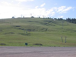
Today, there are around 14 ski lifts (including five at the Seebuck, among them a six-seater chairlift) and over 50 kilometres (31 mi) of downhill runs up to a "black" level of difficulty.
Part of the cross-country skiing trail from Schonach to Belchen runs between Feldberg and Seebuck.
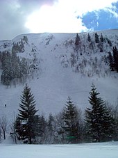
The Feldberg, like many low mountain ranges, is often underestimated in terms of its alpine dangers.
The main dangers in the Feldberg region are sudden falls in temperature, storms or slipping on smooth, icy ground.
The mountainsides of the Zastler valley are particularly prone, but they also occur on leeward slopes like the Feldseekessel at Seebuck, the Herzogenhorn and the Baldenweger Buck.
Snowfall driven by western winds forms cornices on the downwind sides of ridges (e. g. the Zastler Wechte), which can break off.
During the Cold War there were many antennas on a military tower at the summit, but these were removed some years ago.