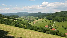
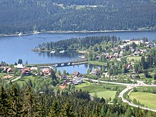
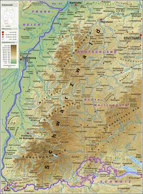
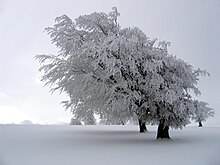
Black Forest
The exposed basement in the west, predominantly made up of metamorphic rocks and granites, was, despite its rugged topography, easier to settle and appears much more open and inviting today with its varied meadow valleys.
Based on that, the Central Black Forest is bounded by the Kinzig in the north and the line from Dreisam to Gutach in the south, corresponding to the Bonndorf Graben zone and the course of the present day B 31.
They are incised by valleys, especially those of the Nagold river system, into individual interfluves; a narrow northwestern finger extends to beyond the Enz near Neuenbürg and also borders the middle reaches of the Alb to the west as far as a point immediately above Ettlingen.
The Central Black Forest (153) is mainly restricted to the catchment area of the River Kinzig above Offenburg as well as the Schutter and the low hills north of the Elz.
On the western edge a descending, step-fault-like, foothill zone borders the Upper Rhine Graben consisting of rocks of the Triassic and Jurassic periods.
The most resistant surface strata on the stepped terrain of the grinden uplands and the heights around the upper reaches of the Enz, which have been heavily eroded by the tributaries of the Murg, is the silicified main conglomerate (Middle Bunter).
Especially in this direction snow accumulated on the shaded and leeward slopes of the summit plateau to form short cirque glaciers that made the sides of these funnel-shaped depressions.
Its rural beauty as well as the sense of tradition of its inhabitants attracted many artists in the 19th and early 20th centuries, whose works made the Black Forest famous the world over.
The works of the Gutach artist colony around Wilhelm Hasemann were widely admired, their landscape and genre motifs capturing the character of the Black Forest.
With the permission of the manor, glassblowers operated simple glass production facilities as "wandering huts" (Wanderhütten), the locations of which were relocated when the local resources were available.
At Schwarzwald Hotel Adler in Häusern, three generations of chefs from the same family have defended the award from the first year the Michelin Guide selected restaurants in Germany until today.[when?
[39] The game has grown organically, and there are many regional variations, but in recent years the establishment of a Cego Black Forest Championship has led to official tournament rules being defined.
Rather, the precipitation rises quickly even in the lower regions and is disproportionately heavy on the rainier western side of the mountains.The wettest areas are the highlands around the Hornisgrinde in the north and around the Belchen and Feldberg in the south, where annual rainfall reaches 1,800–2,100 mm.
During the winter months, frequent high pressure means that the summits are often bathed in sunshine, while the valleys disappear under a thick blanket of fog as a result of pockets of cold air (temperature inversion).
[53] In spring, summer and autumn an extensive network of hiking trails and mountain bike routes enable different groups of people to use the natural region.
Their framework is a network of long-distance paths with main routes and side branches, many of which were laid out in the early 20th century by the Black Forest Club (Schwarzwaldverein).
After 1950, circular walks were constructed to meet the changing demand, initially from the relatively dense railway network and, later, mainly from locally established hiking car parks.
The total network of tracks amounts to around 23,000 kilometres (14,000 mi), and is maintained and overseen by volunteers of the Black Forest Club (figures from Bremke, 1999, p. 9), which is the second largest German hiking association.
From this early precision engineering a formerly important phonographic industry developed in the 20th century; the history of leisure electronics is presented in the German Phono Museum in St. Georgen.
This arm of tourism is controversial due to the high number of accidents and the wide-ranging noise pollution[59] and has been restricted through the introduction of speed limits and by placing certain roads out of bounds.
The Baden Black Forest Railway has linked Offenburg with Konstanz on Lake Constance since 1873, running via Hausach, Triberg, St. Georgen, Villingen and Donaueschingen.
Since January 2006, the Black Forest Tourist organisation, Schwarzwald Tourismus, whose head office is in Freiburg, has been responsible for the administration of tourism in the 320 municipalities of the region.
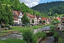
Popular tourist destinations include Baden-Baden, Freiburg, Calw (the birth town of Hermann Hesse), Gengenbach, Staufen, Schiltach, Haslach and Altensteig.
Heidegger wrote and edited some of his philosophical works in a small hut in the Black Forest,[64] and would receive visitors there for walks, including his former pupil Hannah Arendt.
The small mining settlement of Wittichen near Schenkenzell in the upper Kinzig valley had many pits from which miners dug baryte, cobalt and silver of many kinds.
Compared with the Harz and Ore Mountains the quantities of silver extracted in the Black Forest were rather modest and reached only about ten percent of that produced in the other silver-mining regions.
For several centuries logs from the Black Forest were rafted down the Enz, Kinzig, Murg, Nagold and Rhine rivers for use in the shipping industry, as construction timber and for other purposes.
This is evidenced today by a number of glassblowing houses e.g. in the Hoellental in Todtnau and Wolfach and the Forest Glass Centre in Gersbach (Schopfheim), which is open to visitors.
The initial disadvantage of their remote location, which led to the development of precision-engineered wooden handicrafts, became a competitive advantage because of their access to raw materials: timber from the forest and metal from the mines.
As part of a structural support programme the Baden State Government founded the first clockmaking school in 1850 in Furtwangen to ensure that small artisans were given good training and thus better sales opportunities.