Fertile Crescent
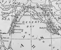
The Fertile Crescent (Arabic: الهلال الخصيب) is a crescent-shaped region in the Middle East, spanning modern-day Iraq, Israel, Jordan, Lebanon, Palestine, and Syria, together with northern Kuwait, south-eastern Turkey, and western Iran.
[3][4] The Fertile Crescent is believed to be the first region where settled farming emerged as people started the process of clearance and modification of natural vegetation to grow newly domesticated plants as crops.
[6][7][8][9][10][11] He wrote:[6] It lies like an army facing south, with one wing stretching along the eastern shore of the Mediterranean and the other reaching out to the Persian Gulf, while the center has its back against the northern mountains.
Historian Thomas Scheffler has noted that Breasted was following a trend in Western geography to "overwrite the classical geographical distinctions between continents, countries and landscapes with large, abstract spaces", drawing parallels with the work of Halford Mackinder, who conceptualised Eurasia as a 'pivot area' surrounded by an 'inner crescent', Alfred Thayer Mahan's Middle East, and Friedrich Naumann's Mitteleuropa.
[12] In current usage, the Fertile Crescent includes Israel, Palestine, Iraq, Syria, Lebanon, Egypt, and Jordan, as well as the surrounding portions of Turkey and Iran.
Around the outer boundary are the Anatolian and Armenian highlands to the north, the Sahara Desert to the west, Sudan to the south, and the Iranian plateau to the east.
The Saharan pump theory posits that this Middle Eastern land bridge was extremely important to the modern distribution of Old World flora and fauna, including the spread of humanity.
From ancient times empires arose and fell in the Tigris–Euphrates river basin, including Sumer, Akkad, Babylonia, Assyria, and the Abbasid Caliphate.
[15] Since the Bronze Age, the region's natural fertility has been greatly extended by irrigation works, upon which much of its agricultural production continues to depend.
[19][21][22][23][24][25][26] Similar arguments do not hold true for the Basques and Canary Islanders of the same time period, as the studies demonstrate those ancient peoples to be "clearly associated with modern Europeans".
[19] The studies further suggest a diffusion of this diverse population away from the Fertile Crescent, with the early migrants moving away from the Near East—westward into Europe and North Africa, northward to Crimea, and northeastward to Mongolia.
Instead, the view now supported by a preponderance of evidence is that it occurred by actual migration out of the region, coupled with subsequent interbreeding with indigenous local populations whom the migrants came in contact with.