Financial District, Manhattan
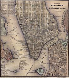
The City of New York was created in the modern-day Financial District in 1624, and the neighborhood roughly overlaps with the boundaries of the New Amsterdam settlement in the late 17th century.
The Financial District is part of Manhattan Community Board 1, which also includes five other neighborhoods (Battery Park City, Civic Center, Greenwich South, Seaport, and Tribeca).
Thus, it has small streets "barely wide enough for a single lane of traffic are bordered on both sides by some of the tallest buildings in the city", according to one description, which creates "breathtaking artificial canyons".
Attractions include the gold vault beneath the Federal Reserve and that "staring down at the trading floor was as exciting as going to the Statue of Liberty".
City authorities realize its importance, and believed that it has "outgrown its neoclassical temple at the corner of Wall and Broad streets", and in 1998 offered substantial tax incentives to try to keep it in the Financial District.
The Bowling Green area was described as "Wall Street's back yard" with poor people, high infant mortality rates, and the "worst housing conditions in the city".
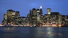
[104] As a result of the construction, looking at New York City from the east, one can see two distinct clumps of tall buildings—the Financial District on the left, and the taller Midtown neighborhood on the right.
[105] Business writer John Brooks in his book Once in Golconda considered the start of the 20th century period to have been the area's heyday.
Writing in The Death and Life of Great American Cities in 1961, urbanist Jane Jacobs described a "deathlike stillness that settles on the district after 5:30 and all day Saturday and Sunday".
The general pattern is for several hundred thousand workers to commute into the area during the day, sometimes by sharing a taxicab[110] from other parts of the city as well as from New Jersey and Long Island, and then leave at night.
"[111] During the past two decades there has been a shift towards greater residential living areas in the Financial District, with incentives from city authorities in some instances.
[111] The discount retailer named Job Lot used to be located at the World Trade Center but moved to Church Street; merchants bought extra unsold items at steep prices and sold them as a discount to consumers, and shoppers included "thrifty homemakers and browsing retirees" who "rubbed elbows with City Hall workers and Wall Street executives"; but the firm went bust in 1993.
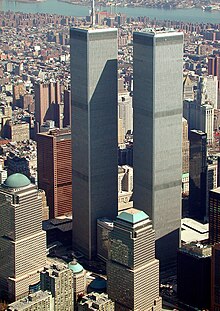
[117] When the World Trade Center was destroyed on September 11, 2001, it left an architectural void as new developments since the 1970s had played off the complex aesthetically.
Abandoned coffee carts, glazed with dust from the collapse of the World Trade Center, lay on their sides across sidewalks.
Most subway stations were closed, most lights were still off, most telephones did not work, and only a handful of people walked in the narrow canyons of Wall Street yesterday morning.Still, the NYSE was determined to re-open on September 17, almost a week after the attack.
[19] After September 11, the financial services industry went through a downturn with a sizable drop in year-end bonuses of $6.5 billion, according to one estimate from a state comptroller's office.
[116] To guard against a vehicular bombing in the area, authorities built concrete barriers, and found ways over time to make them more aesthetically appealing by spending $5000 to $8000 apiece on bollards.
Pedestrians easily slip through groups of them as they make their way onto Wall Street from the area around historic Trinity Church.
[120][121] Additionally, in 2007, the Maharishi Global Financial Capital of New York opened headquarters at 70 Broad Street near the NYSE, in an effort to seek investors.
[11] In 2007 the French fashion retailer Hermès opened a store in the Financial District to sell items such as a "$4,700 custom-made leather dressage saddle or a $47,000 limited edition alligator briefcase".
[128] For census purposes, the New York City government classifies the Financial District as part of a larger neighborhood tabulation area called Battery Park City-Lower Manhattan.
[129] Based on data from the 2010 United States Census, the population of Battery Park City-Lower Manhattan was 39,699, an increase of 19,611 (97.6%) from the 20,088 counted in 2000.
Based on this calculation, as of 2018[update], Financial District and Lower Manhattan are considered high-income relative to the rest of the city and not gentrifying.
[141] In the New York State Assembly, the neighborhood is in the 61st, 65th, and 66th districts,[140] represented respectively by Charles Fall, Grace Lee, and Deborah Glick.
[132]: 14 The concentration of fine particulate matter, the deadliest type of air pollutant, in Financial District and Lower Manhattan is 0.0096 mg/m3 (9.6×10⁻⁹ oz/cu ft), more than the city average.
[132]: 13 In Financial District and Lower Manhattan, 4% of residents are obese, 3% are diabetic, and 15% have high blood pressure, the lowest rates in the city—compared to the citywide averages of 24%, 11%, and 28% respectively.
[132]: 6 The percentage of Financial District and Lower Manhattan students excelling in math rose from 61% in 2000 to 80% in 2011, and reading achievement increased from 66% to 68% during the same time period.
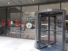
[132]: 6 [133]: 24 (PDF p. 55) Additionally, 96% of high school students in Financial District and Lower Manhattan graduate on time, more than the citywide average of 75%.
[168] The following New York City Subway stations are located in the Financial District:[169] The largest transit hub, Fulton Center, was completed in 2014 after a $1.4 billion reconstruction project necessitated by the September 11, 2001, attacks, and involves at least five different sets of platforms.
[172] The Lower Manhattan Development Corporation started operating a free shuttle bus, the Downtown Connection, in 2003;[173] the route circulates around the Financial District during the daytime.