Fishkill Creek
It rises in the town of Union Vale and flows generally southwest to a small estuary on the Hudson just south of Beacon.
While the creek is not impounded for use in any local water supply, it remains a focus of regional conservation efforts as a recreational and aesthetic resource, especially since the lower Fishkill watershed has been extensively developed in the last two decades.
[4] At the park's south end it flows into Furnace Pond, named for an iron mine that was once nearby, and then into the town of Beekman.
[5] It flows westerly through more woods and swamps to where it receives the Sylvan Lake outlet brook just east of the Taconic State Parkway.
From here it meanders under the Metro-North Beacon Line south of Hopewell Junction where it receives Whortlekill Creek.
[6] It parallels another state road, NY 82, through a wooded, undeveloped area for several miles to where it receives its longest tributary, Sprout Creek, at the Fishkill town line.
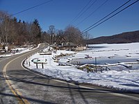
It widens into a series of large pools south of Brinckerhoff, at the foot of Honness Mountain where NY 52 crosses.
It then turns to the southwest again and receives Clove Creek, a tributary that rises in Fahnestock State Park to the south and drains the Putnam County portion of the Fishkill watershed, just before it flows under Interstate 84.
[7] Beyond the interstate it continues southwest alongside the base of the northern slopes of Fishkill Ridge, the northernmost end of the Hudson Highlands.
In Putnam County the largest town represented is Philipstown, whose northwestern section (the Clove Creek watershed) drains into the Fishkill.
The Innisfree Garden landscape in Pleasant Valley, near the north end of the watershed, is irrigated with water pumped from Tyrrell Lake.
In addition, 20 miles (32 km) of the Appalachian Trail runs along the southern fringe of the watershed, much of it on other protected lands or corridor owned by the National Park Service.
[14] Based on weather reports from the Institute of Ecosystem Studies (IES) near Millbrook and Dutchess County Airport in Wappinger, both just outside it to the north and west respectively, the watershed has the humid continental climate typical of much of the Northeast.
This means the rain in Dutchess County and the watershed is ten times more acidic than the natural 5.2 reading for precipitation.
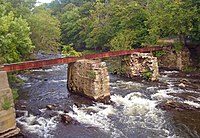
It was an iron bowstring truss bridge built shortly after the Civil War that carried South Avenue across the Fishkill.
Threatened species in the creek and watershed include the bald eagle, Blanding's turtle, least bittern, pied-billed grebe, stiff-leaf goldenrod, swamp cottonwood and blazing star.
[25] The Mid-Hudson Valley region underlying most of Fishkill Creek consists of sedimentary rocks such as shales, sandstones, siltstones and dolomitic limestones that formed during the Cambrian and Ordovician periods of the Paleozoic Era, roughly 450–540 million years ago.
These rocks become modified into metamorphic equivalents as a result of the formation of the Appalachian Mountains, which left large thrust faults in the area, the further east one gets from the Hudson.
In the late 17th century, two New York City merchants, Francis Rombout and Gulian Verplanck, bought 85,000 acres (34,000 ha), most of it in the creek's watershed, from the local Indians.
Troops were on continuous alert should the British Army try to push up through the Highlands to the south and retake the Hudson Valley, a move that could have cut the colonies in half.
[32] "[I]ts waters can be secured more quickly than those of any other supply of equal amount" in the state, the commission wrote in its 1904 report.
[32] The city ultimately decided not to use the Fishkill and instead acquired the land to build Ashokan Reservoir on Esopus Creek in Ulster County, across the Hudson.
In 1975, just as development of the lower watershed was beginning to accelerate, the United States Geological Survey closed the Hopewell Junction stream gauge.
A 1992 study predicted that if current demographic and hydrologic trends continue both the Fishkill and Sprout could expect to have an annual weeklong dry period by 2035.
The Environmental Protection Agency has been monitoring cleanup efforts of the volatile organic compounds at the site and considers them to be progressing according to schedule.
[20] An ongoing concern is the IBM facility in East Fishkill, which dumps its wastewater into Gildersleeves Brook, a tributary of Wiccopee Creek.
Within four years the plant had become the state's top water polluter by pounds of pollutants in the 3.2 million US gallons (12,000 m3) the plant releases into the creek every day, as production expanded due to demand for the chips, which power the PlayStation 3 video game console, primarily copper, lead and nitrates.
In 2004 the company settled a suit brought by local residents who argued that a contractor's dumping of perchloroethylene had led to an increase in cancer and other diseases.
Researchers have so far been unable to determine if some phenomena reported downstream, such as increased lead levels in crustaceans, are the result of the IBM discharges.
Recommendations made were to expand and maintain riparian buffer along the stream while protecting it against encroaching land use, and to find a way to balance groundwater withdrawals and discharges.