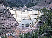
Flaming Gorge Dam
Operated to provide long-term storage for downstream water-rights commitments, the dam is also a major source of hydroelectricity and is the main flood-control facility for the Green River system.
The dam and reservoir have fragmented the upper Green River, blocking fish migration and significantly impacting many native species.
Water released from the dam is generally cold and clear, as compared to the river's naturally warm and silty flow, further changing the local riverine ecology.
Contrary to its namesake, Flaming Gorge, the dam actually lies in steep, rapid-strewn Red Canyon in northeastern Utah, close to where the Green River cuts through the Uinta Mountains.
[6] The project itself was the indirect result of a system of agreements signed by the seven U.S. states and two Mexican provinces in the early 20th century dividing the flow of the Colorado River among them.
[6] Well before the CRSP's inception in 1956, the Bureau had begun to look for suitable reservoir sites along the upper Colorado and tributaries such as the Green, San Juan and Gunnison Rivers.
One of the earlier proposals was called Echo Park Dam, at the confluence of the Green and Yampa Rivers within the Dinosaur National Monument in northwestern Colorado.
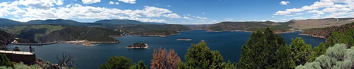
A dam would still be built on the Green River, just 50 miles (80 km) upstream near a brilliant red-rock canyon called Flaming Gorge.
The building of Flaming Gorge Dam started just a few months after the CRSP was approved in Congress, when President Dwight D. Eisenhower pressed a button on his desk in the White House and set off the first blast in Red Canyon.
In 1992, the release patterns from the dam were placed under legal constraints due to a biological opinion to protect endangered fish species.
As originally built, the spillway suffered cavitation damage caused by the high velocity of water rushing over the concrete lining.
[17] By halting floods and artificially increasing low flows, Flaming Gorge Dam has changed the characteristics of the Green River tremendously, especially above its confluence with the Yampa River: "The deafening roar of the spring flood through the Canyon of Lodore in Dinosaur National Monument is subdued to the point that the sound no longer conveys a sense of the power that created this very place.
The cold and clear water releases have caused loss of sandbars, bank erosion, and as a result crucial habitat of four species of native fish in parts of the Green River have been lost.
On August 28, 2008, the Bureau of Reclamation prepared an EIS (Environmental Impact Statement) on the operation of the dam to meet the river flow required by Section 7 of the Endangered Species Act.
About 28 miles (45 km) of the Green River below the dam is designated as a "Blue Ribbon Trout Fishery", below which the water tends to be warmer and more suitable for native species.
[citation needed] One contentious proposal to augment the water supply is via a 501-mile (806 km) pipeline from Flaming Gorge Reservoir to southeastern Wyoming and thence to eastern Colorado.
Although eastern Colorado is lower in elevation than Flaming Gorge Reservoir, the water would have to be pumped over the Rocky Mountains, making the project a net power consumer.
The proposal has caused significant disputes over water rights with about 87 percent of Wyoming residents polled opposing the project.