Rocky Mountain National Park
[6] The history of Rocky Mountain National Park began when Paleo-Indians traveled along what is now Trail Ridge Road to hunt and forage for food.
[27] A geographical anomaly is found along the slopes of the Never Summer Mountains where the Continental Divide forms a horseshoe–shaped bend for about 6 miles (9.7 km), heading from south–to–north but then curving sharply southward and westward out of the park.
[6][28] The sharp bend results in streams on the eastern slopes of the range joining the headwaters of the Colorado River that flow south and west, eventually reaching the Pacific.
[36] Thirty miles of the Continental Divide National Scenic Trail loop through the park and pass through alpine tundra and scenery.
Bridal Veil Falls is a scenic point and trail accessible from the Cow Creek trailhead, at the Continental Divide Research Center.
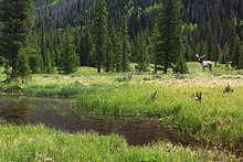
Sprague Lake is a popular place for birdwatching, hiking and viewing the mountain peaks, along with camping at the Glacier Basin campground.
[45] The Pool is a large turbulent water pocket formed below where Spruce and Fern Creeks join the Big Thompson River.
[48] Enos Mills, the main figure behind the creation of Rocky Mountain National Park, enjoyed walking to Lily Lake from his nearby cabin.
[49] The complex interactions of elevation, slope, exposure and regional-scale air masses determine the climate within the park,[50][51] which is noted for its extreme weather patterns.
[50] Sudden dramatic changes in the weather may occur during the summer, typically due to afternoon thunderstorms that can cause as much as a 20 °F drop in temperature and windy conditions.
[53] The stated objective: "develop and apply decision support tools that use NASA and other data and models to assess vulnerability of ecosystems and species to climate and land use change and evaluate management options.
During the Paleozoic era, western North America was submerged beneath a shallow sea, with a seabed composed of limestone and dolomite deposits many kilometers thick.
Concurrently, in the period from 500 to 300 million years ago, the region began to sink while lime and mud sediments were deposited in the vacated space.
The area now known as Colorado was eventually transformed from being at the bottom of an ocean to dry land again, giving yield to another fossiliferous rock layer known as the Denver Formation.
Streams and glaciations during the Quaternary period cut through the older sediment, creating mesa tops and alluvial plains, and revealing the present Rocky Mountains.
[62] Colorado has one of the most diverse plant and animal environments of the United States, partially due to the dramatic temperature differences arising from varying elevation levels and topography.
[66][67] The park's biodiversity includes afforestation and reforestation, ecology, inland bodies of water, and mammals, while its ecosystems are managed for nature conservation, environmental education and public recreation purposes.
[72] Some of the mammals that inhabit the montane ecosystem include snowshoe hares, coyotes, cougars, beavers, mule deer, moose, bighorn sheep, black bears, and Rocky Mountain elk.
Mammals of the subalpine zone include bobcats, cougars, coyotes, elk, mule deer, chipmunks, shrews, porcupines and yellow-bellied marmots.
Many flowering plants of the tundra have dense hairs on stems and leaves to provide wind protection or red-colored pigments capable of converting the sun's light rays into heat.
Some plants take two or more years to form flower buds, which survive the winter below the surface and then open and produce fruit with seeds in the few weeks of summer.
Their enclosed algal cells can photosynthesize at any temperature above 32 degrees Fahrenheit (0 °C), and the outer fungal layers can absorb more than their own weight in water.
Adaptations for survival amidst drying winds and cold temperatures may make tundra vegetation seem very hardy, but in some respects it remains very fragile.
[75] Mammals that live on the alpine tundra, or visit during the summer season, include bighorn sheep, elk, badgers, pikas, yellow-bellied marmots, and snowshoe hares.
[75] The riparian ecosystem runs through the montane, subalpine, and alpine tundra zones and creates a foundation for life, especially for species that thrive next to streams, rivers, and lakes.
[79] Overgrazing by elk has become a major problem in the park's riparian areas, so much so that the NPS fences them out of many critical wetland habitats to let willows and aspens grow.
[108] An increase in average temperature in the Rocky Mountain region has been correlated to a decrease in snowfall that melts earlier in the year, attributing to drier summers and longer fire seasons.
Along with small, prescribed burns, other fuel management practices include removing low hanging branches and forest thinning in general.
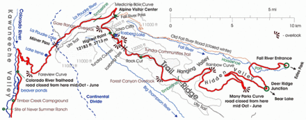
[115] The road is the highest continuously paved highway in the country,[116] and includes many large turnouts at key points to stop and observe the scenery.
[119] Due to the extended winter season in higher elevations, Trail Ridge Road between Many Parks Curve and the Colorado River Trailhead is closed much of the year.