North Sea flood of 1953
Realising that such infrequent events could reoccur, the Netherlands and the United Kingdom carried out large studies on strengthening of coastal defences.
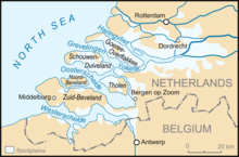
Such land relies heavily on sea defences and was worst affected, recording 1,836 deaths and widespread damage.
[2] More than 230 deaths occurred on seacraft along Northern European coasts as well as on ships in deeper waters of the North Sea.
[11] From midday on 31 January 1953, water was driven from the Northern reaches of the North Sea between Norway and Scotland by a strong North-West gale.
On the night of 1 February 1953 around 3 a.m., many dykes in the province of Zeeland and adjacent areas of South Holland and North Brabant proved unable to resist the floodwaters.
Many people who had survived the first flood died, as the houses whose rooftops they had sheltered on collapsed due to the persistent water pressure.
At that time, the government did not yet know that Schouwen-Duiveland, Goeree-Overflakkee and Tholen were almost completely under water, and no large-scale rescue operations had yet taken place.
At the same time, thousands of Dutch soldiers, administrators, aid workers and volunteers arrived to carry out coordinated actions in the disaster area.
[14] Foreign helicopters and amphibious vehicles also came into action on Tuesday, but the vast majority of rescue operations had already been completed by then.
The following broadcast from the Royal Netherlands Meteorological Institute (KNMI) was made at 6.15pm (18:15) on 31 January 1953 on Hilversum Radio: Over the northern and western parts of the North Sea, a strong gale rages between northwest and west.
It is expected that the storm will continue for the whole night, and given this fact, this afternoon at 5.30pm the areas of Rotterdam, Willemstad and Bergen op Zoom have been warned for dangerous high water.Another warning was broadcast shortly before midnight on 31 January 1953, followed by the Wilhelmus, after which broadcasts ceased for the evening, as was standard in the Netherlands at the time.
The most extensive flooding occurred on the islands of Schouwen-Duiveland, Tholen, Sint Philipsland, Goeree-Overflakkee, the Hoeksche Waard, Voorne-Putten and Alblasserwaard.
The mayor's plan was successful, as the ship was lodged firmly into the dyke, reinforcing it against failure and saving many lives.
It was found that the flooding could have been 4 feet (1.2 m) higher; the Rijkswaterstaat's plan concerning the protection and strengthening of the dikes was accepted.
[16] As a result, authorization was granted for the Delta Works, an elaborate project to enable emergency closing of the mouths of most estuaries, to prevent flood surges upriver.
[25] The fishing village of Crovie, Banffshire, built on a narrow strip of land along the Moray Firth, was abandoned by many, as large structures were swept into the sea.
The surge raced down the east coast into the mid-to-southern North Sea, where it was amplified by shallower waters.
[26] Some 41 people died at Felixstowe in Suffolk when wooden prefabricated homes in the West End area of the town were flooded.
Police Officers Charles Lewis and Leonard Deptford received George Medals for their part in rescue work.
[29] Reis Leming, a US airman, and USAF Staff Sergeant Freeman A Kilpatrick were also awarded the George Medal for rescuing respectively 27 and 18 people at South Beach, Hunstanton.
[32] In south-west Essex, water overspilled the Royal Docks into Silvertown, where it drained into the sewers but flooded back in Canning Town and Tidal Basin.
[33] The village of Creekmouth on Barking Creek, the mouth of the Roding, was wholly flooded by the sea surge and later demolished.
The total death toll at sea for the UK, including the 135 lost in the sinking of MV Princess Victoria, is estimated at 224.
Called the Delta Works (Dutch: Deltawerken), it is designed to protect the estuaries of the rivers Rhine, Meuse and Scheldt.
In 2013 a service was held at Chelmsford Cathedral to mark the 60th anniversary of the Great Flood, attended by Anne, Princess Royal.