Phytochorion
[3] Systems used to classify vegetation can be divided in two major groups: those that use physiognomic-environmental parameters and characteristics and those that are based on floristic (i.e. shared genera and species) relationships.
The term "phytochorion" (Werger & van Gils, 1976)[6] is especially associated with the classifications according to the methodology of Josias Braun-Blanquet, which is tied to the presence or absence of particular species,[7] mainly in Africa.
[8] Taxonomic databases tend to be organized in ways which approximate floristic provinces, but which are more closely aligned to political boundaries, for example according to the World Geographical Scheme for Recording Plant Distributions.
In the late 19th century, Adolf Engler (1844-1930) was the first to make a world map with the limits of distribution of floras, with four major floral regions (realms).
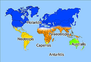
[16] Botanist Ronald Good (1947) identified six floristic kingdoms (Boreal or Holarctic, Neotropical, Paleotropical, South African, Australian, and Antarctic), the largest natural units he determined for flowering plants.
They suggest that the previous inclusion of exotic species did not significantly affect their mapping and found that the cleaned data revealed the same floristic realms.