Forest Lakes, Arizona
Forest Lakes is a small unincorporated community in Coconino County in the northern part of the U.S. state of Arizona.
It is located on the edge of the Mogollon Rim and is in close proximity to several recreational lakes within the Apache-Sitgreaves National Forest, and is named for such.
Heavy demand for the metal from the United States federal government helped ensure steady mining operations into the 1960s, when the family turned to logging to sustain their income.
[4] With the construction of numerous recreational lakes in the area, demand for vacation homes grew and spurred the creation of 10 additional units to the subdivision, with the last being created in May 1969.
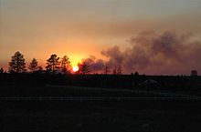
[5] On the afternoon of June 18, 2002, a fire - later determined to be set by an arsonist - was spotted near Cibecue, 27 miles (43 km) southeast of Forest Lakes.
While the fire rapidly grew to cover 10,000 acres (4,000 ha), there was no immediate threat to the Forest Lakes area.
The resultant blaze, the Chediski Fire, was considerably closer, 14 miles (23 km) south of Forest Lakes.
On June 22, the fires combined and moved further northward, threatening several communities including Show Low, Heber-Overgaard and Pinetop-Lakeside.
[6] The blaze moved to within 0.5 miles (0.80 km) of Forest Lakes on June 28, but efforts to save the community prevailed and no homes in the settlement were damaged.
The Forest Lakes Estates subdivision as recorded on the Coconino County Assessor's maps, has an area of approximately 1.89 square miles (4.9 km2), all land.
Immediately south of Forest Lakes is the Mogollon Rim, a steep escarpment ranging from 1,000 to 2,000 feet from the base to the highest plateau.