Mansa, Zambia
The first Fort Rosebery, however was situated in the Luapula Valley around 1900, where most of the province's population live, near Mambilima.
the town has grown considerably in population but not in prosperity since a decrease in employment in the mines of the Copperbelt forced a return to the land in areas such as the Luapula Province.
Mansa lacks industries since the battery factory closed in 1994, and in the absence of employment opportunities, chitemene (a form of subsistence farming) has degraded the surrounding woodlands appreciably.
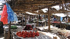
Nevertheless, as a commercial hub serving the whole province, the town is home to a daily market, banks, warehouses, a number of large stores and dealers, and a Shoprite supermarket.
[1] Mansa features a humid subtropical climate (Köppen: Cwa)[4] with clear wet and dry seasons.
[1] The Luapula which forms the border is crossed by a passenger ferry to the north-west at Kasenga, and by a bridge to the south at Chembe, but this connects through Congolese territory via Zambia's notorious and frequently impassable Congo Pedicle road only to the Copperbelt.
Public transport is restricted to buses traveling between towns on the main highways listed above.
PLARD I was a programme run in collaboration with the Ministry of Agriculture and Cooperatives and the Government of Finland.
The aim of PLARD II is to help increase income and food security for the people of Luapula Province by improving the institutional capacity of MAL at the provincial and district levels.
PLARD II overall objective is: To achieve an efficient, competitive and sustainable agricultural and fisheries sector, ensuring increased income and food security for the people of Luapula Province.