Fort St. John, British Columbia
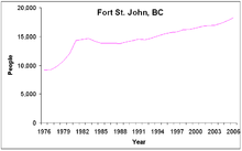
The most populous municipality in the Peace River Regional District, the city encompasses a total area of about 22 km2 (8.5 sq mi) with 21,465 residents recorded in the 2021 Census.
Established in 1794 as a trading post, Fort St. John is the oldest European-established settlement in present-day British Columbia.
This community lasted until 1925 when the river ceased to be the main avenue of transportation and the fort was moved closer to where settlers were establishing homesteads.
The new town was constructed at Fish Creek, northwest of the present community, on the new trail to Fort Nelson.
The present site for the town was firmly established after he donated 2.0 ha (5 acres) for a Roman Catholic church and additional land for a hospital.
Prairies lie to the east and north, while to the west the Rocky Mountains form a rain shadow.
Fort St. John, along with neighboring cities of Chetwynd, Tumbler Ridge, and Dawson Creek, are within Peace River Country, a large geographic area of British Columbia and Alberta.
The Peace River valley provides opportunities for farming, in contrast to the rugged mountains to the west.
The frost-free period is much longer east of the mountains than west, and thus the Peace River area including Fort St. John can grow crops that cannot be grown in most of the province such as wheat and canola.
Fort St. John is a transportation hub and industrial centre serving BC Hydro's nearby hydro-electric facilities, the W.A.C.
The 2001 Canadian census recorded 9,985 income-earners over the age of 15 residing in Fort St. John; of these, 4,500 worked full-time throughout the year.
The high participation rate stems from the relatively young population, much of which was attracted by the area's high-paying oil and gas industry.
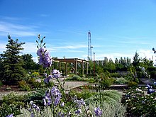
[29] As the urban centre for approximately 20,000 people, much of the region's recreational and cultural facilities are located in town.
Within the city, Centennial Park groups much of these facilities in a central location close to residences and businesses.
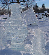
All ice surfaces can be removed to provide event space in excess of 140,000 square feet.
[32] The mayor and one city councillor represent Fort St. John on the board of directors of the Peace River Regional District.
[33] Seven board of education trustees, for representation on School District 60 Peace River North, are also elected by the city.
[34][35] Fort St. John is situated in the Peace River North provincial electoral district and is represented by Pat Pimm in the Legislative Assembly of British Columbia.
Federally, Fort St. John is located in the Prince George—Peace River riding, which is represented in the House of Commons by Conservative Party Member of Parliament Bob Zimmer, a former high school teacher who lives in Fort St. John.
During that year, compared to the provincial average, the RCMP reported much higher crime rates in Fort St. John for cocaine, cannabis, non-sexual assaults, property damage, and arson related offences.
However, the city had lower crime rates for robbery, theft from motor vehicles, and business break-and-enters.
Greyhound Bus lines, which had a bus stop in the city, operated a route along the highway, north to Whitehorse (via Fort Nelson) and south to Dawson Creek, until the company stopped operations in Western Canada in 2018.
[citation needed] The following People and Military Units have received the Freedom of the City of Fort St. John.