Fortress of Louisbourg
[1] The original settlement was founded in 1713 by settlers from Terre-Neuve, and initially called Havre à l'Anglois.
By the mid-1740s Louisbourg, named for Louis XIV of France, was one of the most extensive (and expensive) European fortifications constructed in North America.
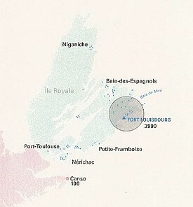
[2] The site was supported by two smaller garrisons on Île Royale located at present-day St. Peter's and Englishtown.
It was captured by British colonists in 1745, and was a major bargaining chip in the negotiations leading to the 1748 treaty ending the War of the Austrian Succession.
This reconstruction work provided jobs for unemployed coal miners, but relied on expropriating an entire community known as West Louisbourg.
[5] The earlier of the two projects was intended to protect the site from rising water and to restore parts of the fortress.
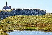
[6] The Fortress of Louisbourg National Historic site is operated by Parks Canada as a living history museum.
A fur trading post was established on the site from 1651 to 1659, but Île Royale languished under French rule as attention was focused on the St. Lawrence River/Great Lakes colony of Canada (which then comprised parts of what is now Quebec, Ontario, Michigan, Ohio, Indiana, Wisconsin and Illinois), Louisiana (which encompassed the current Mississippi Valley states and part of Texas), and the small agricultural settlements of mainland Acadia.
The Treaty of Utrecht in 1713 gave Britain control of part of Acadia (peninsular Nova Scotia) and Newfoundland; however, France maintained control of its colonies at Île Royale, Île Saint-Jean (now Prince Edward Island), Canada and Louisiana, with Île Royale being France's only territory directly on the Atlantic seaboard (which was controlled by Britain from Newfoundland to present-day South Carolina) and it was strategically close to important fishing grounds on the Grand Banks of Newfoundland, as well as being well placed for protecting the entrance to the Gulf of St.
The harbour, being ice-free and well protected, soon became a winter port for French naval forces on the Atlantic seaboard and they named it Havre Louisbourg after King Louis XIV.
The New England forces left, taking with them the famous Louisbourg Cross, which had hung in the fortress chapel.
It soon became the largest Royal Navy base on the Atlantic coast and hosted large numbers of British army regulars.
[8] Britain's American colonies were expanding into areas claimed by France by the 1750s, and the efforts of French forces and their First Nation allies to seal off the westward passes and approaches through which American colonists could move west soon led to the skirmishes that developed into the French and Indian War in 1754.
[9] The fortress was used by the British as a launching point for its 1759 Siege of Quebec that culminated in the Battle of the Plains of Abraham.
[18] In 1961, the government of Canada decided to undertake a historical reconstruction of one-fifth of the town and fortifications with the aim being to recreate Louisbourg as it would have been at its height in 1744.
Some craftsmen came from other countries but most of the reconstruction work was completed by locals, including unemployed coal miners from the industrial Cape Breton area.
According to one source, accuracy was assured by a review of "750,000 pages of documents and 500 maps and plans have been copied from archives in France, England, Scotland, the United States and Canada".
The Fortress of Louisbourg was the capital for the colony of Île-Royale,[26] and was located on the Atlantic coast of Cape Breton Island near its southeastern point.
The location for the fortress was chosen because it was easy to defend against British ships attempting to either block or attack the St. Lawrence River, at the time the only way to get goods to Canada and its cities of Quebec and Montreal.
[27] For this reason, it has been given the nicknames ‘Gibraltar of the North’ or the ‘Dunkirk of America.’ The fort was also built to protect France's hold on one of the richest fishing grounds in the world, the Grand Banks.
One hundred and sixteen men, ten women, and twenty-three children originally settled in Louisbourg.
[36] Louisbourg's commercial success was able to bring ships from Europe, The West Indies, Quebec, Acadia, and New England.
[37] The fort itself cost France 30 million French livres, which prompted King Louis XV to joke that he should be able to see the peaks of the buildings from his Palace in Versaille.
The Maurepas Gate, facing the narrows, connected the fishing establishments, dwellings and cemeteries on Rocheford Point and was elaborately decorated as it was very visible to arriving ships.
Disconnected from the main fort, yet still a part of Louisbourg, a small island in the harbour entrance was also fortified.
During the 1700s, Louisbourg boasted the finest hospital in North America and the second-largest building in the fort town.