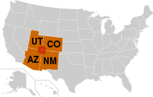
Four Corners
The boundary was legally defined as a line running due south from the southwest corner of Colorado Territory, which had been created in 1861.
[2] In 1925, some 57 years after Congress had first attempted to specify the spot, the problems surrounding the originally misplaced marker were brought up before the US Supreme Court.
In order to amicably remedy this original surveying error, the US Supreme Court then redefined the point of the Four Corners, officially moving the Four Corners point roughly 1,800 feet (550 m) east, to where the original survey had first held it to be all along, and where it remains to this day, duly marked.
[3] This initial survey error has resulted in some longstanding misunderstandings about the correct location of the Four Corners marker, some of which remain to this day.
This makes it a center for weather systems, which stabilize on the plateau then proceed eastward through Colorado and into the central states.
The economic hub, largest city, and only metropolitan area in the region is Farmington, New Mexico.
[13] Other cities in the region include Cortez and Durango in Colorado; Monticello and Blanding in Utah; Kayenta and Chinle in Arizona; and Shiprock, Aztec, and Bloomfield in New Mexico.
The Black Mesa and Lake Powell Railroad, which connects a power plant with a coal mine near Kayenta, comes near the Four Corners.