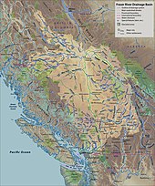
Fraser River
After running northwest past 54° north, it makes a sharp turn to the south at Giscome Portage, meeting the Nechako River at the city of Prince George, then continues south, progressively cutting deeper into the Fraser Plateau to form the Fraser Canyon from roughly the confluence of the Chilcotin River, near the city of Williams Lake, southwards.
Hell's Gate, located immediately downstream of the town of Boston Bar, is a famous portion of the canyon where the walls narrow dramatically, forcing the entire volume of the river through a gap only 35 metres (115 feet) wide.
The Fraser then flows past Maple Ridge, Pitt Meadows, Port Coquitlam, and north Surrey.
While the vast majority of the river's drainage basin lies within British Columbia, a small portion in the drainage basin lies across the international border in Washington in the United States, namely the upper reaches of the tributary Chilliwack and Sumas rivers.
[14] The Water Survey of Canada currently operates 17 gauge stations that measure discharge and water level along the majority of the mainstem from Red Pass just downstream of Moose Lake in the Mount Robson Provincial Park, to Steveston in Vancouver at the river mouth.
[7] Further studies and hydraulic models have estimated the maximum discharge of the Fraser River, at Hope during the 1894 flood, as within a range of about 16,000 to 18,000 cubic metres per second (570,000 to 640,000 cu ft/s).
[7] The Maris Pacifici map published in 1589 features on the west coast of North-America the first ever representation of two major coastline features: the delta of the Fraser River labeled "Baia de las isleas" and the mouth of the Columbia River identified as "Rio Grande".
In spite of limited evidence of Francis Drake expedition whereabouts in the Pacific Northwest, BC history commentator Sam Bawlf posited that the Ortelius map was a proof that Drake sighted the mouth of the Fraser and came through the Strait of Juan de Fuca.[18].
[19] The existence of the river, but not its location, had been deduced during the 1791 voyage of José María Narváez, under Francisco de Eliza.
The lower Fraser was revisited in 1824 when the Hudson's Bay Company sent a crew across Puget Sound from its Fort George southern post on the Columbia River.
The trading post original location would soon become the first ever mixed ancestry and agricultural settlement in southern British Columbia on the Fraser (Sto:lo) river.
[22] Much of British Columbia's history has been bound to the Fraser, partly because it was the essential route between the Interior and the Lower Coast after the loss of the lands south of the 49th Parallel with the Oregon Treaty of 1846.
[23] It was the site of its first recorded settlements of Aboriginal people (see Musqueam, Sto:lo, St'at'imc, Secwepemc and Nlaka'pamŭ), the site of the first European-Indigenous mixed ancestry settlement in southern British-Columbia (see Fort Langley), the route of multitudes of prospectors during the Fraser Canyon Gold Rush and the main vehicle of the province's early commerce and industry.
Its banks are rich farmland, its water is used by pulp mills, and a few dams on some tributaries provide hydroelectric power.
The Fraser River is known for the fishing of white sturgeon, all five species of Pacific salmon (chinook, coho, chum, pink, sockeye), as well as steelhead trout.
[26] A white sturgeon weighing an estimated 500 kilograms (1,100 lb) and measuring 3.76 metres (12 ft 4 in) was caught and released on the Fraser River in July 2012.
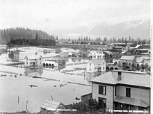
[29][30] After European settlement, the first disastrous flood in the Lower Mainland (Fraser Valley and Metro Vancouver) occurred in 1894.
Cool temperatures in March, April, and early May had delayed the melting of the heavy snowpack that had accumulated over the winter season.
Several days of hot weather and warm rains over the holiday weekend in late May hastened the thawing of the snowpack.
Major flooding occurred once again in 1972 due to a significant spring freshet, primarily impacting regions around Prince George, Kamloops, Hope and Surrey.