Ecoregion
Ecoregions cover relatively large areas of land or water, and contain characteristic, geographically distinct assemblages of natural communities and species.
Biogeographic provinces may originate due to various barriers, including physical (plate tectonics, topographic highs), climatic (latitudinal variation, seasonal range) and ocean chemical related (salinity, oxygen levels).
[1][2][3][4][5] The phrase "ecological region" was widely used throughout the 20th century by biologists and zoologists to define specific geographic areas in research.
Subsequent regional papers by the co-authors covering Africa, Indo-Pacific, and Latin America differentiate between ecoregions and bioregions, referring to the latter as "geographic clusters of ecoregions that may span several habitat types, but have strong biogeographic affinities, particularly at taxonomic levels higher than the species level (genus, family)".
[7][8][9] The specific goal of the authors was to support global biodiversity conservation by providing a "fourfold increase in resolution over that of the 198 biotic provinces of Dasmann (1974) and the 193 units of Udvardy (1975)."
[12] Using recent advances in satellite imagery the ecoregion perimeters were refined and the total number reduced to 846 (and later 844), which can be explored on a web application developed by Resolve and Google Earth Engine.
[14] Omernik (2004) elaborates on this by defining ecoregions as: "areas within which there is spatial coincidence in characteristics of geographical phenomena associated with differences in the quality, health, and integrity of ecosystems".
An example of the algorithmic approach is Robert Bailey's work for the U.S. Forest Service, which uses a hierarchical classification that first divides land areas into very large regions based on climatic factors, and subdivides these regions, based first on dominant potential vegetation, and then by geomorphology and soil characteristics.
For example, the WWF ecoregions were developed to aid in biodiversity conservation planning, and place a greater emphasis than the Omernik or Bailey systems on floral and faunal differences between regions.
There are many attempts to respond to ecosystems in an integrated way to achieve "multi-functional" landscapes, and various interest groups from agricultural researchers to conservationists are using the "ecoregion" as a unit of analysis.
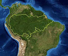
WWF (World Wildlife Fund) ecologists currently divide the land surface of the Earth into eight biogeographical realms containing 867 smaller terrestrial ecoregions (see list).
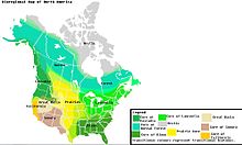
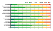
Forests, grasslands (including savanna and shrubland), and deserts (including xeric shrublands) are distinguished by climate (tropical and subtropical vs. temperate and boreal climates) and, for forests, by whether the trees are predominantly conifers (gymnosperms), or whether they are predominantly broadleaf (Angiosperms) and mixed (broadleaf and conifer).
[20] In 2007, TNC and WWF refined and expanded this scheme to provide a system of comprehensive near shore (to 200 meters depth) Marine Ecoregions of the World (MEOW).
The freshwater major habitat types reflect groupings of ecoregions with similar biological, chemical, and physical characteristics and are roughly equivalent to biomes for terrestrial systems.
The Global 200, a set of ecoregions identified by WWF whose conservation would achieve the goal of saving a broad diversity of the Earth's ecosystems, includes a number of areas highlighted for their freshwater biodiversity values.