Fucking Grove, Bristol
[1] The charter included a formal survey of the county boundary, which corresponded to the existing town lands.
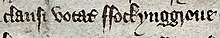
[3] Since this was a legal document, later surveys and perambulations continue to employ the term—albeit in later published descriptions the 'F' was changed to a 'P', presumably because of the embarrassment caused by reproducing a rude word within polite publications.
The exact location and boundaries of Fucking Grove were determined by Roger Leech (University of Southampton) in his reconstruction of the topography and built environment of the St Michael's Hill area of Bristol.
The title of the seminar related to the seeming reluctance of previous historians to discuss the grove, to place it within the modern city, or to consider what it might reveal about pre-modern sexual practices.
Both Whore's Street and Gropecunt Lane (a name found in many English medieval towns) reference sex work.
It is about 200 feet above the river and the docks on what early modern pictures suggest to be a green and open or lightly wooded area.
Roger Leech's topographical survey suggest that the grove contained no dwelling houses until the late eighteenth century.
[17] Today the grove lies within Clifton, an area developed during the Georgian era by wealthy Bristolians who wished to escape the smoke, smells and pollution of the city centre.
Provided those having sex were married, were discreet and avoided public nudity, the Church had no reason to condemn such activity.