Fused grid
The Radburn pattern emerged in 1929 about thirty years following the invention of the internal combustion engine powered automobile and in anticipation of its eventual dominance as a means for mobility and transport.
When horses serve a city and draw chariots singly or in pairs, or, similarly, carts for a variety of transportation and processional functions, straight line travel becomes imperative; turns force a sluggish pace and cumbersome manoeuvres that reduce their efficiency of movement.
The creation of the Radburn pattern is attributed to Clarence Stein but has a lineage of ideas that preceded it in Raymond Unwin and Barry Parker's work that included the use of cul-de-sac and crescent street types.
The "loop and lollipop" label may be a more applicable descriptor of later interpretations of the Radburn model that appear to lack structure and to overlook key elements of the original concept such as its emphasis on pedestrian priority, for example.
The two dominant network patterns, the grid and Radburn, have been debated by planners, transportation engineers and social observers on grounds that include issues of defence, aesthetics, adaptability, sociability, mobility, health, safety, security and environmental impact.
More importantly, ground observation of cities shows that the mix of buildings and their varied street alignments as well as open spaces with their size variations coupled with constant redevelopment, suppress the monotony of the grid.
A Radburn-type network inherently includes a variety of city blocks and terminating vistas and, consequently, preempts criticism centered on monotony and lack of end-closure.
Two newer aesthetic criticisms of the Radburn model emerged in the 1980s: the absence of a street "wall" or "enclosure" and the repetitiveness of housing unit forms as found in suburban districts.
[citation needed] Judging the visual outcome of prosperity using historic streetscape criteria of cities with a different socioeconomic makeup would make the verdict predictable and practically meaningless.
In the case of early Huguenot settlements, sameness of houses on identical grid patterns was pursued as a means of expressing the social equality of all inhabitants – a community goal.
[15] Also, many early grid-plan towns and suburbs such as Windermere, Florida, Dauphin, Manitoba, and St. Andrews, New Brunswick exhibit grid layouts and very low densities.
More significant criticisms of the grid and the Radburn patterns were put forward based on the new urban transportation context of unprecedented levels of motorised mobility that raises issues of traffic congestion, collisions, accessibility, connectivity, legibility for pedestrian and driver, noise disturbance, car travel extent, air and water pollution, and greenhouse gas emissions.
The introduction of mechanized personal transport in large numbers during the 20th century tested every existing network's characteristics and their capacity to function satisfactorily for mobility and for city living in general.
The earliest known evidence of people realizing uninterrupted, orthogonal grid plans had disadvantages was found in Pompeii,[18] which was a city on the south eastern coast of Italy destroyed by a major volcanic eruption in 79 AD.
The number and speed of vehicles on roads have increased a lot since Pompeii was destroyed, and people have gotten better at recording and understanding traffic problems, so the issues with grids are more obvious.
The study concluded that the non-hierarchical, traditional layout generally shows lower peak speeds and shorter, but more frequent intersection delays than the hierarchical pattern.
Many parts of Paris, France, for example, exhibit a highly irregular block dimensions and a wide range of street orientations not easily grasped by visitors.
By contrast, derivatives of the Radburn-type network, particularly the non-cellular and strictly dendrite variety, are inflexible and force transit routes that are often long and circuitous resulting in an inefficient and costly service.
As was seen earlier under congestion, grid-type patterns induce longer trip times that are primarily due to stops at the characteristic and frequent four-way intersections.
In judging the two currently disputed network concepts it would appear that neither has all the requisite elements needed for adequately responding to the new urban transportation context of extensive motorized mobility.
Based on these sets of issues, the identified advantages of alternative patterns and the ideas of 20th century theorists, the fused grid assembles several elements from these precedents into a complete stencil.
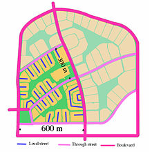
The most intensive land uses such as schools, community facilities, high-density residential uses, and retail are located in the center of the plan, reached by twinned roads which connect longer, district destination points.
This synthesis of inherited network traditions and ideas is accomplished through the application of two practical means: a rectilinear, orthogonal geometry, a key characteristic of the grid, and the use of two street types that have generally been associated with the Radburn-type subdivisions.
In addition to these three factors that may impact on resident's health – noise, air quality, and physical activity – a fourth one, proximity to natural open spaces, has emerged as a significant contributor.
[46] From these studies it can be inferred that a neighbourhood layout based on the fused grid model may confer these health and well-being benefits to residents because it incorporates green open spaces as integral parts of its pedestrian circulation network.
Within the 16 ha quadrant, the discontinuous character of the streets and the possible combination of cul-de-sac and loop types provide sufficient latitude to the site plan designer to lay out an adapted version of the fused grid.
The analysis results show that the impermeable areas of the three layouts – assuming roads, building foot prints and sidewalks to be impervious surfaces – ranged from 34.7% of fused grid to 35.8% of the conventional suburban to 39% of the grid-like pattern.
The reduction in street length and the systematic use of open spaces as structural elements of the layout increase the potential of greater water permeability in the Fused Grid.
In most of these cases, acknowledging the constrains of an existing built environment, the key fused grid characteristic of a traffic impermeable centre is evident along with the primacy and continuity of pedestrian-only links to the remainder of the inherited street system.
A similar debate has also been taking place in Europe and particularly the UK, where the term filtered permeability[49] was coined to describe urban layouts which maximise ease of movement for pedestrians and cyclists, but seek to restrain it for motor vehicles.