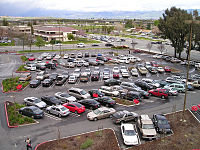
Impervious surface
The island of Catalina located West of the Port of Long Beach has put extensive effort into capturing rainfall to minimize the cost of transportation from the mainland.
[3] The COVID-19 pandemic gave birth to proposals for radical change in the organisation of the city,[4] being the drastic reduction of the presence of impermeable surfaces and the recovery of the permeability of the soil one of the elements of the Manifesto for the Reorganisation of the city, published in Barcelona by architecture and urban theorist Massimo Paolini and signed by 160 academics and 350 architects.
The percentage imperviousness, commonly referred to as PIMP in calculations, is an important factor when considering drainage of water.
Land use coefficient methods commonly are used because planning and zoning maps that identify similar areas are, increasingly, available in GIS formats.
[6] The Multi-Resolution Land Characteristics Consortium (MRLCC) defines a developed area as being covered by at least 30 percent of constructed materials[10]).
[12] Granato (2010)[6] provides a table with 8 population-density relations from the literature and a new equation developed by using data from 6,255 stream basins in the USGS GAGESII dataset.
[14][15] Detection of impervious areas using deep learning in conjunction with satellite images has emerged as a transformative method in remote sensing and environmental monitoring.
Deep learning algorithms, particularly convolutional neural networks (CNNs), have revolutionized our capacity to identify and quantify impervious surfaces from high-resolution satellite imagery.
These models can automatically extract intricate spatial and spectral features, enabling them to discriminate between impervious and non-impervious surfaces with exceptional accuracy.
The NLCD[19] provides land-cover statistics that can be used as a qualitative measure of the prevalence of different land covers that may act as natural impervious areas.
Open water may act as a natural impervious area if direct precipitation is routed through the channel network and arrives as stormflow at the site of interest.
Wetlands may act as a natural impervious area during storms when groundwater discharge and saturation overland flow are a substantial proportion of stormflow.
These stormflows may occur even during storms that do not meet precipitation volume or intensity criteria to produce runoff based on nominal infiltration rates.
Similarly, Taylor (1982)[21] did infiltrometer tests in areas before and after suburban development and noted that topsoil alteration and compaction by construction activities reduced infiltration rates by more than 77 percent.
This article incorporates public domain material from websites or documents of the United States Geological Survey and the Federal Highway Administration.