Galápagos Islands
The Galápagos are famous for their large number of endemic species, which were studied by Charles Darwin in the 1830s and inspired his theory of evolution by means of natural selection.
Thus far, there is no firm evidence that Polynesians or the Indigenous peoples of South America reached the islands before their accidental discovery by Bishop Tomás de Berlanga in 1535.
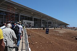
With the growing importance of ecotourism to the local economy, the airport modernized in the 2010s, using recycled materials for any expansion and shifting entirely to renewable energy sources to handle its roughly 300,000 visitors each year.
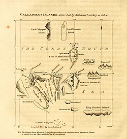
[5] The name is first attested as the Spanish/Latin hybrid Insulae de los Galopegos ("Islands of the Turtles") on the map of the Americas in Abraham Ortelius's Theater of the Lands of the World (Theatrum Orbis Terrarum), first published in 1570.
The names they chose to honour British kings, nobles, and naval officers of their eras continued to be used for the major islands until recently and are still used for many of the smaller islets.
[9][10][11] The Galápagos Archipelago is characterized by numerous contemporaneous volcanoes, some with plume magma sources, others from the asthenosphere, possibly due to the young and thin oceanic crust.
For instance, Isabela Island includes six major volcanoes, Ecuador, Wolf, Darwin, Alcedo, Sierra Negra and Cerro Azul, with most recent eruptions ranging from 1813 to 2008.
[20] The 18[21] main islands (each having a land area at least 1 km2) of the archipelago (with their English names) shown alphabetically: Mosquera is also home to one of the largest colonies of sea lions in the Galapagos, and there have been occasional orca whale sightings around the islet.
The following table for the especially wet year of 1969 shows the variation of precipitation in different places of Santa Cruz Island: Most of the Galápagos is covered in semi-desert vegetation, including shrublands, grasslands, and dry forest.
A few of the islands have high-elevation areas with cooler temperatures and higher rainfall, which are home to humid-climate forests and shrublands, and montane grasslands (pampas) at the highest elevations.
[33] A 1952 archaeological survey by Thor Heyerdahl and Arne Skjølsvold found potsherds and other artifacts from several sites on the islands that they claimed suggested visitation by South Americans during the pre-Columbian era.
Radiocarbon dates from the sites placed them in the post-Spanish era and preliminary paleoenvironmental analysis showed no disturbance older than 500 years before present, suggesting no evidence from the survey that the islands were visited prior to their Spanish discovery in 1535.
They found the islands they visited uninhabited and so arid and barren that two men and ten horses died for lack of fresh water and the rest were forced to subsist on cactus pads.
[citation needed] Until the early 19th century, the archipelago was often used as a hideout by (mostly English) pirates who attacked Spanish treasure fleets carrying gold, silver, and supplies from Peru to Panama and Spain.
[40] In 1793, during the early French Revolutionary Wars, the British captain James Colnett described the flora and fauna of Galápagos and suggested the islands could be used as a base for whalers operating in the Pacific.
According to later accounts, Watkins managed to survive by hunting, growing vegetables and trading with visiting whalers[45][46] before stealing a longboat from a whaling ship, impressing five of its crew as his "slaves", and navigating to Guayaquil on the Ecuadorian mainland.
[47] In 1818, the Nantucket whaleship Globe under Captain George Washington Gardner discovered a "mother lode" of sperm whales some thousand miles west of the South American coast approximately at the equator.
Gen. José de Villamil, the founder of the Ecuadorian Navy, led the push to colonize and settle the islands before Ecuador's neighbors or the European empires could occupy them.
[53] The second voyage of HMS Beagle under captain Robert FitzRoy was undertaken to better survey the coasts and harbours of South America for the British Navy's Hydrographic Department.
It reached the Galápagos on 15 September 1835 and—while surveying its islands, channels, and bays—the captain and others on the crew observed the geology, plants, and wildlife on Floreana, Isabela, and Santiago before continuing on their round-the-world expedition on 20 October.
José Valdizán and Manuel Julián Cobos tried a new colonization, beginning the exploitation of a type of lichen found in the islands (Roccella portentosa) used as a coloring agent.
Over the course of a whole year, from September 1904, an expedition of the Academy of Sciences of California, led by Rollo Beck, stayed in the Galápagos collecting scientific material on geology, entomology, ornithology, botany, zoology, and herpetology.
[64] Ecuador's staunch resistance to a US purchase or bases in the islands can be credited to Chilean diplomacy, which in turn was informally backed on this issue by Great Britain and Germany.
Ecuadorian laws provided all colonists with the possibility of receiving twenty hectares each of free land, the right to maintain their citizenship, freedom from taxation for the first ten years in Galápagos, and the right to hunt and fish freely on all uninhabited islands where they might settle.
During World War II, Ecuador authorized the United States to establish a naval base in Baltra Island, and radar stations in other strategic locations.
The largest ethnic group is composed of Ecuadorian Mestizos, the mixed descendants of Spanish colonists and indigenous Native Americans, who arrived mainly in the last century from the continental part of Ecuador.
Soon other travel companies brought in tour ships and yachts, and local fishermen began converting their wooden boats for rudimentary cruising with guests.
In 1986, the 70,000 square kilometers (27,000 sq mi) of ocean surrounding the islands was declared a marine reserve, second in size only to Australia's Great Barrier Reef.
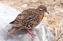
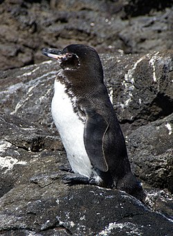
[75] Noteworthy species include: Introduced plants and animals, such as feral goats, cats, and cattle, brought accidentally or willingly to the islands by humans, represent the main threat to Galápagos.
Some of the most harmful introduced plants are the guayaba or guava (Psidium guajava), avocado (Persea americana), cascarilla (Cinchona pubescens), balsa (Ochroma pyramidale), hill raspberry (Rubus niveus), various citrus (orange, grapefruit, lemon), floripondio, higuerilla (Ricinus communis) trees and the elephant grass, Pennisetum purpureum.