Gaular
The original municipality was identical to the Indre Holmedal parish (prestegjeld) which included the sub-parishes (sokn) of Bygstad, Sande, and Vik.
The official blazon is "Vert, a pale argent engrailed" (Norwegian: På grøn grunn ein sølv stolpe laga med taggesnitt).
This means the arms have a green field (background) and the charge is a vertical bar with scalloped edges.
The charge has a tincture of argent which means it is commonly colored white, but if it is made out of metal, then silver is used.
The municipal council (Kommunestyre) of Gaular was made up of 21 representatives that were elected to four year terms.
It is bordered to the north by the municipalities of Askvoll and Førde, to the east by Balestrand, to the south by Høyanger, and to the west by Fjaler.
The Gaula River flows west through the municipality and empties into the Dalsfjorden near the village of Bygstad.
The European route E39 highway runs through the centre of Sande south to the city of Bergen, a distance of 150 kilometres (93 mi) (with a ferry between the villages of Lavik and Oppedal across the Sognefjorden).
From near the town of Førde, drivers start on a sightseeing journey with cultural attractions that date from the 19th century to the present day's city environment.
The districts of Holsen and Haukedalen are typical of Western Norwegian farming communities that have created a picturesque cultivated landscape.
Rørvik Mountain is on the road and it has fascinating stone walls and a marvellous view over the Haukedalen valley.
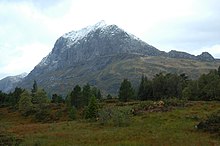
The breathtaking contrasts of steep mountainsides, winding roads, and waterfalls are characteristic of Western Norway's exceptional scenery.