Gaywood River
[1] Its source is 11 metres above sea level, northwest of the village of Gayton in Derby Fen, Map Reference TF 705 209.
The remnant supports a range of habitats from dry calcareous to damp acidic grasslands and heath which all rely on the river.
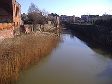
Progressing into its lower reaches and entering the outskirts of King's Lynn, the river banks have been the subject of much flood defence work.
Skirting the southern side of South Wootton, the river passes under the A148 and turns southwards alongside a residential street called Riverside for a short distance before running along the eastern boundary of a sports fields close to King's Lynn Leisure Centre.
The inventor of this system is said to have been one Peter Morrys, a Dutchman, and his system was adopted not only in King's Lynn, but also in Hull and other large towns and London where several of the wooden pipes were dug up in the area of Marble Arch, elm being the favourite wood as it was more capable of standing up to conditions and pressure than cheaper timbers.
Later Kettlemill was used as a coal-fired electricity plant but was eventually demolished to make way for the offices of the Local Drainage Board.
The river now heading westwards again reaches London Road where it is thought once stood another watermill called Town Mill.