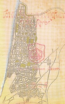
Geddes Plan for Tel Aviv
Patrick Geddes envisioned public gardens surrounded by residential blocks and small streets, with main roads crossing the city from east to west and south to north.
His evolutionary concept of cities alongside his "valley section" regional planning, was synergistic with the Zionist Commission's goal of both founding and historically contextualising a modern Hebrew settlement, helping to "re-establish roots in the ancient homeland".
[4] Geddes' vision for Tel Aviv was to "realize a conurbation as an example of contemporary planning...based on the valley section and integrated villages, towns and large cities - both old and new.
Tertiary tree-lined boulevards were added providing green pedestrian promenades, and finally networks of deliberately narrow lanes arranged in an irregular non-aligned 'pinwheel' fashions to discourage non-residential traffic[9] allowed access to the interior of the "superblocks"[7] that much of the land was divided into.
[17] Reflecting on his work in Balrampur, Geddes laid plans for a town square (now Dizengoff Circle) to link the old parts of Tel Aviv and by extension Jaffa to the new development in the north.
[18] While "the basic layout of large blocks created by north-south and east-west cross streets that were intersected by narrower access lanes was adhered to",[3] Geddes plan was amended significantly by the time of its official approval in 1938.