Geelong
[7] It is the administrative centre for the City of Greater Geelong municipality, which is Port Phillip's only regional metropolitan area, and covers all the urban, rural and coastal reserves around the city including the entire Bellarine Peninsula[note 1] and running from the plains of Lara in the north to the rolling hills of Waurn Ponds to the south, with Corio Bay to the east and the Barrabool Hills to the west.
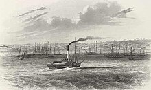
[13] He charted the entire bay, including the Geelong area, believing he was the first to sight the huge expanse of water, but in a rush to reach Sydney before winter set in, he left Port Phillip on 3 May.
[13] Hume and Hovell had been contracted to travel overland from Sydney to Port Phillip, and having achieved this, they stayed the night and began their return journey two days later on 18 December.
[29] In 1835, John Batman used Indented Head as his base camp,[30] leaving behind several employees whilst he returned to Tasmania (then known as Van Diemen's Land) for more supplies and his family.
In this same year, Buckley surrendered to the party led by John Helder Wedge and was later pardoned by Lieutenant-Governor Sir George Arthur, and subsequently given the position of interpreter to the natives.
[30] Captain Foster Fyans was commissioned as the local Police Magistrate in 1837 and established himself on the Barwon River at the site of the area of present-day Fyansford.
In 1839, Charles Sievwright, the newly appointed Assistant Protector of Aborigines (for the western district) sets up camp on the Barwon River near Fyans ford.
[18] On the eve of World War II, the International Harvester works were opened beside Ford at North Shore, along with a grain elevator at nearby Corio Quay, and the Shell Australia oil refinery.
[59] The Waterfront Geelong redevelopment, started in 1994, was designed to enhance use and appreciation of Corio Bay[60] and in 1995 the Barwon River overflowed in the worst flood since 1952.
[62][63][64] In 2004, Avalon Airport was upgraded to accommodate interstate passenger travel, providing a base for low-cost airline Jetstar to serve the Melbourne and Geelong urban areas.
[67] Major projects include the $150-million Westfield Geelong expansion works, involving a flyover of Yarra Street, the city's first Big W store, and an additional 70 new speciality stores; the $37-million Deakin Waterfront campus redevelopment, and the $23-million Deakin Medical School; the $50-million Edgewater apartment development on the waterfront; a number of multimillion-dollar office developments in the CBD; and a new $30-million aquatic centre in Waurn Ponds.
G21 developed 'The Geelong Region Plan - a sustainable growth strategy' Archived 4 October 2011 at the Wayback Machine which was launched by Premier Brumby in 2007.
In addition, major projects such as the Geelong Ring Road Connections and duplication of the Princes Highway West obtained funding due to the combined efforts of the region's municipalities.
To the west are the sandstone-derived Barrabool Hills and basalt Mount Duneed, and the volcanic plains to the north of Geelong extend to the Brisbane Ranges and the You Yangs.
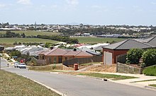
[86] Residential development also spread to Corio and Norlane in the north, with new Housing Commission of Victoria estates built to cater for employees of the new industries.
[93] The average annual rainfall is around 525.2 mm (20.7 in), which makes Geelong one of the driest cities in Australia, owing to the pronounced rain shadow of the Otway Ranges to the south-west.
[94] More than 10,000 businesses employ over 80,000 people in the Geelong region,[19] with manufacturing and processing industries providing around 15,000 jobs, followed by 13,000 in retail, and 8,000 in health and community services.
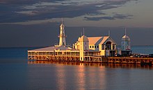
[99] Major tourist attractions include the Waterfront Geelong precinct and Eastern Beach on the shores of Corio Bay, and the National Wool Museum in the city, and more than 30 historical buildings listed on the Victorian Heritage Register.
Corangamite, which roughly includes the southern half of Geelong as well as the Bellarine Peninsula, has traditionally been safe for the Liberal Party, but become more marginal in recent years due to demographic changes and redistributions.
The city is also the birthplace or starting point for a number of notable Australian bands and musicians, such as Barry Crocker, Gyan Evans, Magic Dirt, Jeff Lang, Denis Walter, Chrissy Amphlett, and Helen Garner.
North Geelong Warriors FC are the region's primary soccer club, playing in the National Premier Leagues Victoria competition.
Geelong also has many golf courses, sporting and recreation ovals, and playing fields, as well as facilities for water skiing, rowing, fishing, hiking, and greyhound and harness racing.
[159] Geelong Athletics holds competitions during both the summer and winter, including high-profile events such as Victorian and sometimes national and international track and field meets.
"[161] Geelong is also the birthplace of Bev Francis, an IFBB professional Australian female bodybuilder, powerlifter, and national shot put champion.
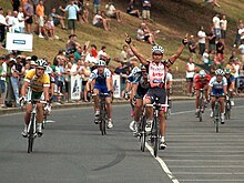
[162][163] The Cadel Evans Great Ocean Road Race, named in honour of the Tour de France winner and 2009 World Champion starts in the city.
[177] The Lewis Bandt Bridge, named in honour of the Ford Australia engineer who is credited as the inventor of the ute (1934), in Geelong is a feature of the new road.
Geelong is a major hub for rail transport in Victoria, having frequent services to and from Melbourne, and being at the junction of the Port Fairy, Western standard gauge and the Geelong-Ballarat lines.
In the past, a rail line connected Geelong city to the Bellarine Peninsula through to Queenscliff, ceasing to operate as a regular passenger service in 1976.
[citation needed] On 23 October 2022 the Tasmanian ferry service, the Spirit of Tasmania, started operating from a new terminal in North Geelong rather than from Port Melbourne.
[189] V/Line services link Geelong with Ballarat, Daylesford, Bendigo, Apollo Bay, the Great Ocean Road, the Twelve Apostles and Warrnambool.