Geotagging
Users may also use a feature that allows them to find nearby Facebook friends by generating a list of people according to the location tracker in their mobile devices.
Because of the requirement for wireless service providers in United States to supply more precise location information for 911 calls by September 11, 2012,[3] more and more cell phones have built-in GPS chips.
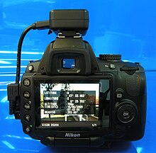
Almost any digital camera can be coupled with a stand-alone GPS and post processed with photo mapping software, to write the location information to the image's exif header.
The GeoSMS standard works by embedding one or more 'geo' URIs in the body of an SMS, for example: RFC 1876 defines a means for expressing location information in the Domain Name System.
LOC resources records can specify the latitude, longitude, altitude, precision of the location, and the physical size of on entity attached to an IP address.
The GeoURL[9] method requires the ICBM tag[10] (plus optional Dublin Core metadata), which is used to geotag standard web pages in HTML format: The similar Geotag format allows the addition of place name and region tags: The RDF method is defined by W3 Group and presents the information in RDF tags:[11] The Geo microformat allows coordinates within HyperText Markup Language pages to be marked up in such a way that they can be "discovered" by software tools.
Such sites allow users to add metadata to an information resource via a set of so-called machine tags (see folksonomy).
In order to integrate geotags in social media and enhance text readability or oral use, the concept of 'meetag' or tag-to-meet has been proposed.
Words in messages on microblogging and social networking services may be tagged by putting "_" before them, either as they appear in a sentence, (e.g. "There is a concert going _montreuxjazzfestival", "the world wide web was invented _cern _geneve", ...) or appended to it.
Searching a list of blogs and pictures tagged using geotag technology allows users to select areas of specific interest to them on interactive maps.
For better integration and readability of geotags into blog texts, the meetag syntax has been proposed, which transforms any word, sentence, or precise geolocalization coordinates prefixed with an underscore into a 'meetag'.
The app Respotter Wiki, launched in 2009, claims to feature Wikipedia searching via a map, also allowing users to interact with people around them, via messaging and reviews, etc.
[16] Following a scientific study[17] and several demonstrative websites,[18][19] a discussion on the privacy implications of geotagging has raised public attention.
[citation needed] According to the study, a significant number of for-sale advertisements on Craigslist, that were otherwise anonymized, contained geotags, thereby revealing the location of high-valued goods—sometimes in combination with clear hints to the absence of the offerer at certain times.
Publishing photos and other media tagged with exact geolocation on the Internet allows random people to track an individual's location and correlate it with other information.
[24] Another newly realized danger of geotagging is the location information provided to criminal gangs and poachers on the whereabouts of often endangered animals.