Earth-centered, Earth-fixed coordinate system
[4] The ECEF that is used for the Global Positioning System (GPS) is the geocentric WGS 84, which currently includes its own ellipsoid definition.
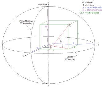
The ECEF coordinate system has the following parameters: An example is the NGS data for a brass disk near Donner Summit, in California.
The reverse conversion is harder: given X-Y-Z can immediately get longitude, but no closed formula for latitude and height exists.
Geocentric coordinates can be used for locating astronomical objects in the Solar System in three dimensions along the Cartesian X, Y, and Z axes.
They are differentiated from topocentric coordinates, which use the observer's location as the reference point for bearings in altitude and azimuth.