Geography of Africa
Africa is a continent comprising 63 political territories, representing the largest of the great southward projections from the main mass of Earth's surface.
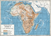
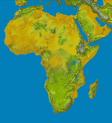
In contrast with other continents, it is marked by the comparatively small area of either very high or very low ground, lands under 180 m (590 ft) occupying an unusually small part of the surface; while not only are the highest elevations inferior to those of Asia or South America, but the area of land over 3,000 m (9,800 ft) is also quite insignificant, being represented almost entirely by individual peaks and mountain ranges.
(So prevalent are these isolated peaks and ridges that a specialised term—Inselberg-Landschaft, island mountain landscape—has been adopted in Germany to describe this kind of country, thought to be in great part the result of wind action.
)[1] As a general rule, the higher tablelands lie to the east and south, while a progressive diminution in altitude towards the west and north is observable.
The largest of these level areas, the Great Karoo, is a dry, barren region, and a large tract of the plateau proper is of a still more arid character and is known as the Kalahari Desert.
It is formed by a widening out of the eastern axis of high ground, which becomes subdivided into a number of zones running north and south and consisting in turn of ranges, tablelands and depressions.
The most striking feature is the existence of two great lines of depression, due largely to the subsidence of whole segments of the Earth's crust, the lowest parts of which are occupied by vast lakes.
Towards the south the two lines converge and give place to one great valley (occupied by Lake Nyasa), the southern part of which is less distinctly due to rifting and subsidence than the rest of the system.
Other volcanic peaks rise from the floor of the valleys, some of the Kirunga (Mfumbiro) group, north of Lake Kivu, being still partially active.
The third division of the higher region of Africa is formed by the Ethiopian Highlands, a rugged mass of mountains forming the largest continuous area of its altitude in the whole continent, little of its surface falling below 1,500 m (4,900 ft), while the summits reach heights of 4400 m to 4550 m. This block of country lies just west of the line of the great East African Trough, the northern continuation of which passes along its eastern escarpment as it runs up to join the Red Sea.
Towards the extreme west the Futa Jallon highlands form an important diverging point of rivers, but beyond this, as far as the Atlas chain, the elevated rim of the continent is almost wanting.
The arid region, the Sahara — the largest hot desert in the world, covering 9,000,000 km2 (3,500,000 sq mi) — extends from the Atlantic to the Red Sea.
The Atlas range, the north-westerly part of the continent, between its seaward and landward heights encloses elevated steppes in places 160 km (99 mi) broad.
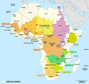
[10] The upper Nile receives its chief supplies from the mountainous region adjoining the Central African trough in the neighborhood of the equator.
Issuing from there, the Nile flows northward, and between the latitudes of 7 and 10 degrees north it traverses a vast marshy level, where its course is liable to being blocked by floating vegetation.
After receiving the Bahr-el-Ghazal from the west and the Sobat, Blue Nile and Atbara from the Ethiopian Highlands (the chief gathering ground of the flood-water), it separates the great desert with its fertile watershed, and enters the Mediterranean at a vast delta.
Traversing this in a majestic northward curve, and receiving vast supplies of water from many great tributaries, it finally turns southwest and cuts a way to the Atlantic Ocean through the western highlands.
These four river basins occupy the greater part of the lower plateaus of North and West Africa — the remainder consists of arid regions watered only by intermittent streams that do not reach the sea.
[1] Of the remaining rivers of the Atlantic basin, the Orange, in the extreme south, brings the drainage from the Drakensberg on the opposite side of the continent, while the Kunene, Kwanza, Ogowe and Sanaga drain the west coastal highlands of the southern limb; the Volta, Komoe, Bandama, Gambia and Senegal the highlands of the western limb.
All the largest tributaries, including the Shire, the outflow of Lake Nyasa, flow down the southern slopes of the band of high ground stretching across the continent from 10° to 12° S. In the southwest, the Zambezi system interlaces with that of the Taukhe (or Tioghe), from which it at times receives surplus water.
The rest of the water of the Taukhe, known in its middle course as the Okavango, is lost in a system of swamps and saltpans that was formerly centred in Lake Ngami, now dried up.
[1] Farther south, the Limpopo drains a portion of the interior plateau, but breaks through the bounding highlands on the side of the continent nearest its source.
[1] Between the basins of the Atlantic and Indian Oceans, there is an area of inland drainage along the centre of the Ethiopian plateau, directed chiefly into the lakes in the Great Rift Valley.
The largest river is the Omo, which, fed by the rains of the Ethiopian highlands, carries down a large body of water into Lake Turkana.
It lies in the Indian Ocean, off the southeast coast of the continent, from which it is separated by the deep Mozambique Channel, 400 km (250 mi) wide at its narrowest point.
Farther south, the heat is to some extent modified by the moisture brought from the ocean, and by the greater elevation of a large part of the surface, especially in East Africa, where the range of temperature is wider than in the Congo basin or on the Guinea coast.
The wide heated plains of the Sahara, and in a lesser degree the corresponding zone of the Kalahari in the south, have an exceedingly scanty rainfall, the winds which blow over them from the ocean losing part of their moisture as they pass over the outer highlands, and becoming constantly drier owing to the heating effects of the burning soil of the interior; while the scarcity of mountain ranges in the more central parts likewise tends to prevent condensation.
[1] The rainfall zones are, however, somewhat deflected from a due west-to-east direction, the drier northern conditions extending southwards along the east coast, and those of the south northwards along the west.
Within the equatorial zone certain areas, especially on the shores of the Gulf of Guinea and in the upper Nile basin, have an intensified rainfall, but this rarely approaches that of the rainiest regions of the world.
[1] The countries bordering the Sahara are much exposed to a very dry wind, full of fine particles of sand, blowing from the desert towards the sea.