Geology of South Africa
The geology of the country is the base for a large mining sector that extracts gold, diamonds, iron and coal from world-class deposits.
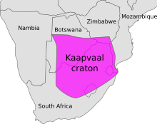
[2] In Neoproterozoic times, much of South Africa stabilized into the large Kalahari Craton that came to form part of the supercontinent Rodinia.
[2] Since the Mesozoic the tectonics of South Africa have been shaped by an initial phase of rifting[4] and then by episodic epeirogenic movements.
[6] The uplift of these margins is tentatively related to far-field compressional stresses that has warped the region as a giant anticline-like lithosphere fold.
[5] Limited erosion means that many of the major relief features of South Africa have existed since the Late Cretaceous.
The western and southern extents of the Supergroup have been folded into a series of longitudinal mountain ranges, by the collision of the Falkland Plateau into what would later become South Africa.
The supergroup consists of a sequence of units, mostly of nonmarine origin, deposited between the Late Carboniferous and Early Jurassic, a period of about 120 million years.