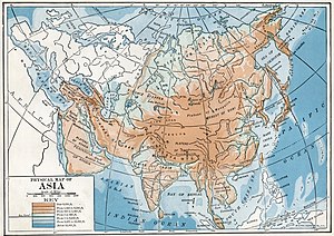
Geography of Asia
The border with Europe starts with the coast of the eastern Mediterranean, even though Turkey in the Near East extends partly into the Aegean Islands and includes Istanbul on the European side of the Bosphorus.
The Pacific islands northeast of Australia more remotely removed from Japan and Korea are Oceania rather than Asia.
Multiple sources give different estimates of the area enclosed by the imaginary border of Asia.
Indonesia to the southeast, a nation consisting of thousands of islands, adds a significant amount of territory to mainland Asia and extends the extreme Asian latitude further south.
The southernmost seabed boundary is 10° 50' S, the latitude of Point A3, the Australia, Indonesia and Papua New Guinea common tripoint.
The three-continent system was an idea devised in Archaic Greece, a time of Greek colonial expansion and trade throughout the Mediterranean and the spread of writing again.
It had been lost during the preceding Greek Dark Ages, a period of piracy at sea and defensive parochialism on land.
There was no systematic definition of "continent;" however, the Greek mariners did make a distinction that was to become one: the islands, nēsoi, versus the mainland, ēpeiros.
It is not surprising that the first continents were "shores," as they are in Herodotus, first historian whose works are extant, who relies on earlier geography now missing except for fragments.
One runs from Phasis in Colchis (Georgia) at the eastern end of the Black Sea around the coast of Asia Minor to Phoenicia.
The southern shore continues the Red Sea and the Nile River, as Darius the Great had constructed a canal between them.
The geographer, Claudius Ptolemaeus, distinguishes between geography, which is "a representation in picture of the whole known world," and chorography ("study of places"), which "treats more fully the particulars.
The idea of the continents preceded the imperial Romans but through them reached to modern time to determine today's geographic views, which are enhancements and refinements of the classical.
Stating that "continents are bounded more properly, when it is possible, by seas than by rivers," Ptolemy defines a three-continent system: Europe, Libya, Asia.
In the north, the border between Asia and Europe is a meridian through the mouth of the Don River northward "to the unknown region.
Other schools equate the word "continent" to geographical "region" when referring to Europe and Asia in terms of physical geography.
[citation needed] In European languages, the term "Asian" more commonly refers to ethnic heritage rather than a strict geographic area.
Asia contains the Indian subcontinent, Iranian Plateau, Arabian Peninsula, as well as a piece of the North American plate in Siberia.
By 2080, around 1 billion people in the cities of South and Southeast Asia are expected to experience around a month of extreme heat every year.
[22]: 1465 There are many coral reefs in the region, and they are highly vulnerable to climate change,[22]: 1459 to the point practically all of them will be lost if the warming exceeds 1.5 °C (2.7 °F).
[22]: 1459 These changes to water cycle also affect vector-borne disease distribution, with malaria and dengue fever expected to become more prominent in the tropical and subtropical regions.
[22]: 1468 While the United States remains the world's largest oil consumer, by 2050 it is projected to move to third place, behind China and India.
[22]: 1470 While nearly half of the world's new renewable energy capacity is built in Asia,[22]: 1470 this is not yet sufficient in order to meet the goals of the Paris Agreement.
[22]: 1471 The United Nations Statistics Division, charged with collecting statistical data on global regions including Asia, publishes a classification standard, United Nations M49, which assigns code numbers to continental regions, areas and countries, based on statistical purposes,[26] and the countries and regions grouped together don't imply any assumption regarding political or other affiliations between the grouped countries.
M49 is a device for collecting useful statistics for the UNSD and is a suggested reference guide offered as a global standard for all agencies and institutions within the various UN departments that might be interested.
The one major exception to the scheme is "Russia," not currently officially in the continental region of Asia, but unofficially partly in it even though classified as Europe.
For example, the UNSD statistical geoscheme does not recognize a "North Asia," but problematic differences in point of view reach down to the country level elsewhere as well.
This sort of paradox only underlines that Asia has no precise definition in the same way that nations do, to whom a mere 100 yards of border may be of great concern.
Splitting a nation would be more problematic; for example, the Ural River is not a well-defined boundary in places; moreover, some geopolitical units straddle it.
Population and area figures for Indonesia do not include Irian Jaya and Maluku Islands, frequently reckoned in Oceania.