Geography of Bulgaria
Even within small parts of the country, the land may be divided into plains, plateaus, hills, mountains, basins, gorges, and deep river valleys.
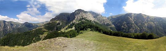
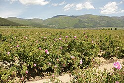
Bulgaria features notable diversity with the landscape ranging from the snow-capped peaks in Rila, Pirin and the Balkan Mountains to the mild and sunny Black Sea coast and southernmost valleys; from the typically continental Danubian Plain (ancient Moesia) in the north to the strong Mediterranean climatic influence in the valleys of Macedonia and in the lowlands in the southernmost of Thrace, the lowest parts of the Upper Thracian Plain, along the Maritsa River, the Southern Bulgarian Black Sea Coast.
[11] The eastern border (378 km) is maritime and encompasses the Bulgarian Black Sea Coast from Cape Sivriburun in the north to the mouth of the Rezovo River in the south.
[10][13] The frontier with North Macedonia runs from the Tumba Peak in the south through the mountains of Ograzhden, Maleshevo, Vlahina and Osogovo up to mount Kitka.
In the relatively small territory of the country there are extensive lowlands, plains, hills, low and high mountains, many valleys and deep gorges.
[14] The main characteristic of Bulgaria's topography is four alternating bands of high and low terrain that extend east to west across the country.
The easternmost sections near the Black Sea are hilly, but they gradually gain height to the west until the westernmost part of the country is entirely high ground.
The highest point is Tarnov Dyal (502 m) on the Shumen Plateau; the average altitude is 178 m.[20] As a result of the rock weathering processes the relief is uneven with fertile alluvial plains along the Danube (Vidinska, Chernopolska, Zlatia, Belenska, Pobrezhie, Aidemirska), and hilly terrain in the remaining area, including plateaus in the east.
The flat relief and the openness of plain to the north facilitate arrival of moist air masses in spring, summer and autumn.
In winter the Danubian Plain falls under the influence of the Eastern European anticyclone, which brings cold Arctic air masses.
[23] The range is highest in its central part, which includes Botev Peak at 2,376 m; the altitude drops slowly to the east until it reaches the sea.
Srednogorie region stretches between the Sub-Balkan valleys in the north and the Rilo-Rhodope Massif in the south and from west to east includes the mountains Zavalska Planina, Viskyar, Lyulin, Vitosha, Plana and Sredna Gora.
[25] The Rhodopes are the most extensive mountain range in Bulgaria, spanning an area of 14,730 km2 with an average altitude of 785 m, characterized with gentle and densely forested slopes.
[33] The northernmost section between the Bulgarian-Romanian border to Shabla has extensive sandy beaches and several coastal lakes, then the elevation rises as the coast reaches Cape Kaliakra, with 70 m high vertical cliffs.
Cape Emine marks the end of the Balkan Mountain and divides the Bulgarian Black Sea coast in northern and southern parts.
[33] All Bulgarian Black Sea islands are situated in the southern coast: St. Anastasia, St. Cyricus, St. Ivan, St. Peter and St. Thomas.
Due to its small area, the influence of the Black Sea only affects a 30–40 km long strip along the coastline, mainly in summer, when the daily breeze circulation is most pronounced.
The Bulgarian mountains and valleys act as barriers or channels for air masses, causing sharp contrasts in weather over relatively short distances.
[39][40] The mean annual temperature in Bulgaria is 10.6 °C and varies from 2.2 °C at the nation's highest peak Musala to 14.7 °C (1991-2021 Climate data) at the town of Sandanski in the southern Struma valley.
The Danubian Plain is characterised by the fertile black earth chernozem, that accounts for 54% of the zone's area, while the Pre-Balkan is dominated by grey forest soils (39%), which have good physical characteristics but are low in organic matter and phosphorus.
[71] More than 92% of them, or 4,5 billion tons,[71] is lignite, which is the lowest rank of coal due to its relatively low heat content but is widely used for electricity generation.
However, there is a huge basin of bituminous coal in Southern Dobruja with estimated reserves of over 1 billion tons but its large depth (1370–1950 m) is an obstacle for its commercial exploitation.
[76] Bulgaria has significant reserves of metal ores, especially copper, zinc and lead, situated mainly in the southern half of the country.
The two largest iron ore mines are located in Kremikovtsi near Sofia and Krumovo, Yambol Province with total reserves of 430 million tons.
[78] Bulgaria possesses important reserves of lead and zinc, of them 60% are situated in the southern reaches of the Rhodope Mountains along the border with Greece at Madan, Zlatograd, Madzharovo, Rudozem, Laki, etc.
[78] The reserves of copper ore are also significant, situated mainly at Asarel Medet near Panagyurishte, Elatsite mine near Etropole (650 million tons), Elshitsa, Medni Rid near Burgas, etc.
Solnitsata, an ancient town located nearby is believed by Bulgarian archaeologists to be the oldest in Europe and was the site of a salt production facility approximately six millennia ago.
[79][80] The reserves of kaolinite are estimated at 70 million tons, situated mainly in north-eastern Bulgaria – Kaolinovo, Todor Ikonomovo, Senovo and Vetovo.
[8] Around 35% of Bulgaria's land area consists of forests,[85] which include some of the oldest individual trees in the world, such as Baikushev's pine and the Granit oak.
The ichthyofauna (fish) of the country has not been fully researched, but there is a rich variety of sturgeons, Black Sea shark, longnose spurdog, thornback ray, common stingray, northern pike, European eel, etc.