Geography of Colombia
It is bordered to the north-west by Panama; to the east by Brazil and Venezuela; to the south by Ecuador and Peru;[1] and it shares maritime limits with Costa Rica, Nicaragua, Honduras, Jamaica, the Dominican Republic, and Haiti.
[2][3] Colombia has a land size of 1,141,748 km2 (440,831 sq mi) and it is the 25th largest nation in the world and the fourth-largest country in South America (after Brazil, Argentina, and Peru).
In the east, the sparsely populated, flat to gently rolling eastern lowlands called llanos cover almost 60 percent of the country's total land area.
This cross section of the republic does not include two of Colombia's regions: the Caribbean coastal lowlands and the Sierra Nevada de Santa Marta, both in the northern part of the country.
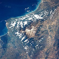
The Sierra Nevada de Santa Marta is a spectacular triangular snowcapped block of rock that towers over the eastern part of this lowland.
[5] Near the Ecuadorian frontier, the Andes Mountains divide into three distinct, roughly parallel chains, called cordilleras, that extend northeastward almost to the Caribbean Sea.
The elevated basins and plateaus of these ranges have a moderate climate that provides pleasant living conditions and in many places enables farmers to harvest twice a year.
The Magdalena River is generally navigable from the Caribbean Sea as far as the town of Neiva, deep in the interior, but it is interrupted midway by rapids.
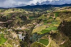
In the Cordillera Oriental, at elevations between 2,500 and 2,700 meters (8,202 and 8,858 ft), three large fertile basins and a number of small ones provide suitable areas for settlement and intensive economic production.
To the north of Bogotá, in the densely populated basins of Chiquinquirá and Boyacá, are fertile fields, rich mines, and large industrial establishments that produce much of the national wealth.
Still farther north, where the Cordillera Oriental makes an abrupt turn to the northwest near the border with Venezuela, the Sierra Nevada de Cocuy, the highest point of this range, rises to 5,493 meters (18,022 ft) above sea level.
The northernmost region of the range around Cúcuta is so rugged that historically it has been easier for residents here to maintain communications and transportation with Venezuela than with the adjacent parts of Colombia.
The Caribbean lowlands consist of all of Colombia north of an imaginary line extending northeastward from the Golfo de Urabá to the Venezuelan frontier at the northern extremity of the Cordillera Oriental.
In the southern part rises the Sierra Nevada de Santa Marta, an isolated mountain system with peaks reaching heights over 5,700 meters (18,701 ft) and slopes generally too steep for cultivation.
Inland from these cities are swamps, hidden streams, and shallow lakes that support banana and cotton plantations for major commodity crops, countless small farms, and, in higher places, cattle ranches.
Barranquilla is located some 25 miles (40 km) from the Caribbean coastline but it is a more developed city, with a greater number of industries and commercial places, widely known for its skilled workers in producing all forms of metalwork and accomplishing construction.
The region also includes the peninsular archipelago of San Andres Island and the Insular Territories of Colombia, which are disputed in part by Nicaragua.
These facilities serve as containment and secure experimentation labs to complement those in Barranquilla and other undisclosed locations within the coast territories.
It comprises the areas outside the continental territories of Colombia and includes the San Andrés y Providencia Department in the Caribbean Sea and the Malpelo and Gorgona islands in the Pacific Ocean.
Starting at the shore of the Pacific Ocean in the west and moving eastward at a latitude of 5 degrees north, a diverse sequence of features is encountered.
In the extreme west are the very narrow and discontinuous Pacific coastal lowlands, which are backed by the Serranía de Baudó, the lowest and narrowest of Colombia's mountain ranges.
In 1855, William Kennish, an engineer and veteran of the British Royal Navy, who had immigrated to the United States and was working for a New York City firm, studied the area and proposed an inter-oceanic river aqueduct and tunnel to connect the Rio Atrato, with its mouth at the Atlantic Ocean, with tributaries and through a tunnel and aqueduct through Nerqua Pass, to flow into Bahía Humboldt at the Pacific Ocean.
In the 1980s, only three percent of all Colombians resided in the Pacific lowlands, a region of jungle and swamp with considerable but little-exploited potential in minerals and other resources.
Its river settlements have access to the major Atlantic ports and consequently are commercially related primarily to the Caribbean lowlands hinterland.
To the west of the Río Atrato rises the Serranía de Baudó, an isolated chain of low mountains that occupies a large part of the region.
Extensive areas of the Caribbean interior are permanently flooded, more because of poor drainage than because of the moderately heavy precipitation during the rainy season from May through October.
The mean temperature ranges between 10 and 19 °C (50.0 and 66.2 °F), and the wet seasons occur in April and May and from September to December, as in the high elevations of the temperate zone.
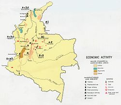
Colombia is the main producer of emeralds and an important participant in gold, silver, iron, salt, platinum, petroleum, nickel, copper, hydropower and uranium extraction.
Historical, geographical, and pictorial records point toward a consistent and progressive depletion of ice-and-snow masses in the Colombian Andes since the end of the "Little Ice Age" in the late 1800s.
[12] Land size: total: 1,138,910 km2 (439,740 sq mi) Land boundaries: total: 6,672 km Coastline: 3,208 km (Caribbean Sea 1,760 km, North Pacific Ocean 1,448 km) Exclusive Economic Zone: total: 808,158 km2 (312,032 sq mi) Climate: tropical along coast and eastern plains; cooler in highlands Terrain: flat coastal lowlands, central highlands, high Andes Mountains, eastern lowland plains Elevation extremes: lowest point: Pacific Ocean 0 m highest point: Pico Cristobal Colon 5,975 m note: nearby Pico Simon Bolivar also has the same elevation Natural resources: petroleum, natural gas, coal, iron ore, nickel, gold, copper, emeralds, hydropower Land use: arable land: 1.43% permanent crops: 1.68% other: 96.89% (2012) Irrigated land: 10,870 km2 (2011) Total renewable water resources: 2,132 km3 (2011) Freshwater withdrawal (domestic/industrial/agricultural): total: 12.65 km3 (55%/4%/41%) per capita: 308 m3/yr (2010) Natural hazards: highlands subject to volcanic eruptions; occasional earthquakes; periodic droughts Environment - international agreements: party to: Antarctic Treaty, Biodiversity, Climate change, Climate Change-Kyoto Protocol, Desertification, Endangered Species, Hazardous Wastes, Marine Life Conservation, Ozone Layer Protection, Ship Pollution, Tropical Timber 83, Tropical Timber 94, Wetlands signed, but not ratified: Law of the Sea Colombia has four main drainage systems: the Pacific drain, the Caribbean drain, the Orinoco Basin and the Amazon Basin.