Geography of Cornwall
The geography of Cornwall (Cornish: Doronieth Kernow) describes the extreme southwestern peninsula of England west of the River Tamar.
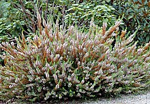
The highest point is Brown Willy at 420 m (1,378 ft), part of the granite Bodmin Moor, of which such intrusions are covered by rough grass, heather and bog flora.
Woodland is prevented from growing on the granite uplands because of the poor soil and the height giving them the full force of the wind and climate.
Lowland stretches are also to be found, particularly along the south coast, sometimes backed by large expanses of towans or dunes such as near Par.
[2] Cornwall was one of the most important mining areas in Europe until the 20th century, due to its intrusions of granite into surrounding sedimentary rocks which resulted in metamorphism and mineralisation.
The south coast is more sheltered and is interrupted by several rias which provide deep water harbours such as Carrick Roads.
One of the lower plant forms in decline locally is the Reindeer lichen, which has been made a priority for protection under the national UK Biodiversity Action Plan.
While traditionally administered as part of Cornwall, the Isles of Scilly are now a separate unitary authority though they are included in the ceremonial county.
Some species of fish are abundant in the coastal waters; the pilchard fishery was of great importance from the late 18th to the early 20th century.
Cornwall has the mildest and sunniest climate in the United Kingdom, as a result of its oceanic setting and the influence of the Gulf Stream.
The county experiences droughts and heat waves with the rest of Europe as they happen, but its location close to the ocean dampens their severity.
Also, European windstorms in the winter usually make landfall on the west coast of Europe, including Cornwall, resulting in severe gales and flooding.
Historical accounts describe the waves of 3 metres (10 feet) in height and significant loss of life and property.