Geography of Dorset
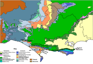
The geology of Dorset is varied; most of the different rocks found in the wider south-east of England outcrop within its boundaries.
The south-east of the county forms part of the Hampshire Basin, an asymmetric syncline covered in sands and gravels of Paleogene age.
The whole of Dorset's coastline is designated part of the Jurassic Coast World Heritage Site, and contains examples of many different coastal landforms, reflecting the variety of the underlying geology.
The rocks outcropping in Dorset are all of sedimentary origin, and were formed in the Jurassic, Cretaceous and Paleogene periods of geological history.
The south-east of the county occupies the western end of the Hampshire Basin, an asymmetric syncline which underlies a large part of central southern England.
The Downs are part of the northern rim of the Hampshire Basin, which dips gently to the southeast from the steep north-facing scarp slope.
The dip slope of the chalk is incised by seasonal streams or winterbornes, which have formed several roughly parallel valleys aligned north to south.
Its boundary is indistinct, but roughly conforms to that part of the catchment area of the River Stour that lies north of the Dorset Downs and west of Cranborne Chase.
The Purbeck Hills are a monocline, a step-like geological fold dating from about 30 million years ago, resulting from the same collision of tectonic plates which built the Alps.
It enters Dorset near the village of Bourton, then flows generally southwards through the Blackmore Vale via the towns of Gillingham and Sturminster Newton.
It leaves the Blackmore Vale in a deep valley which it has cut through the chalk hills; it hence forms the divide between the Dorset Downs to the southwest and Cranborne Chase to the northeast.
It then flows generally southeastwards through Blandford Forum and around the northern suburbs of Bournemouth, to enter the English Channel through Christchurch Harbour.
The River Piddle (alternative name: River Trent) follows a similar and almost parallel course to the Frome, rising a few miles to the east on the chalk downs near the village of Alton Pancras, then flowing roughly southeastwards through chalk and over sands and gravels to reach the English Channel through Poole Harbour.
The River Brit rises north of Beaminster, flows south through Bridport and enters the Channel at West Bay.
Some large country estates, for example Sherborne Castle and Crichel House, have lakes as part of the landscaping of their grounds.
The ball clay workings on the Isle of Purbeck have left behind a legacy of numerous small lakes, the most notable of which is the Blue Pool.
Excluding the shoreline of Poole Harbour, the Dorset coastline is 142 kilometres (88 mi) long[8] and faces the English Channel.
The Dorset coastline contains a great variety of coastal landforms, including cliffs, bays, headlands, a large natural harbour and a barrier beach.
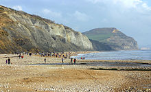
Within the length of Dorset's coast can be found examples of a nearly circular cove (Lulworth Cove), a very clearly exposed and accessible geological fold (Stair Hole), a natural sea arch (Durdle Door), sea stacks (Old Harry Rocks), an active landslip (Black Ven), and numerous and often quite spectacular cliffs, including the highest cliff on England's south coast, Golden Cap.
The Isle of Portland is a tied island lying in the English Channel less than 8 kilometres (5.0 mi) south from Weymouth, at roughly the midpoint along the Dorset coastline.
The Isle of Purbeck is a broad peninsula in the south-east of the county, bounded by the English Channel to the south and east, and by Poole Harbour to the north.
The Purbeck coast is varied and contains sandy bays, headlands of chalk and limestone, and also shales and the small onshore oil well at Kimmeridge.
It was formed about 6,000 years ago after the last Ice Age, as a rising sea-level flooded the valleys of the rivers Frome and Piddle,[9] which now flow into the harbour from the west.
Chesil Beach is composed of shingle and pebbles which are graded in size from the smallest particles in the west to the largest in the east.
A few miles to the southwest at Kimmeridge, a nodding donkey has been pumping up oil from beneath the shale cliffs there since the late 1950s, although yields are declining.
It has been quarried on a large scale since the middle of the 18th century; Dorset's first railway was constructed in 1806 in order to transport the excavated material.


1 Dorset UA
2 Bournemouth, Christchurch and Poole