Geography of Ecuador
Ecuador is one of the smallest countries in South America, but bigger than Uruguay, Guyana, Suriname and French Guiana.
The most populated metropolitan areas of the country are those of Guayaquil, Quito, Cuenca, Manabí Centro (Portoviejo-Manta) and Ambato.
Ecuador is divided into three continental regions—the Costa (coast), Sierra (mountains), and Oriente (east)—and one insular region, the Galápagos Islands (officially Archipiélago de Colón).
The continental regions extend the length of the country from north to south and are separated by the Andes Mountains.
They are noted for their association with Charles Darwin, whose observation of animals here during the voyage of the Beagle led to his formation of the theory of natural selection as a means of evolution.
It is estimated that 98% of the native forest of coastal Ecuador has been eliminated in favor of cattle ranching and other agricultural production, including banana, cacao and coffee plantations.
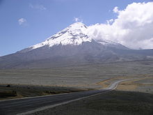
Quito, the capital city, is located in a high mountain valley on the foothills of the Pichincha (volcano).
The town of Baños de Agua Santa features hot springs swimming pools on the foothills of the Tungurahua in the Central Cordillera.
Partial, incomplete table of volcanoes in the north of the Ecuadorian Andes, from north to south: Much of the Oriente is tropical moist broadleaf forest (Spanish: la selva), on the east slopes of the Andes Mountains and descending into the Amazon Basin, with strikingly different upland rainforest with steep, rugged ridges and cascading streams (can be seen around Puyo) and lowland rainforest.
Some 38% of Ecuador's land is forested,[5] and despite a 1.5% annual deforestation rate remains one of the most biodiverse locations on the planet.
The Oriente is also home to a large number of Ecuador's indigenous groups, notably the lowland Quechua, Siona, Secoya, Huaorani, and Cofán.
The rivers rise from snowmelt at the edges of the snowcapped peaks or from the abundant precipitation that falls at higher elevations.
Rivers may slow and widen as they cross the hoyas yet become rapid again as they flow from the heights of the Andes to the lower elevations of the other regions.
The Costa Internal, by contrast, is crossed by perennial rivers that may flood during the rainy season, sometimes forming swamps.
The Guayas River Basin, including land drained by its tributaries, is 40,000 square kilometers in area.
Briefly constricted at Guayaquil by hills, the Guayas widens south of the city and flows through a deltaic network of small islands and channels.
In its upper reaches, the Napo flows rapidly until the confluence with one of its major tributaries, the Coca River, where it slows and levels off.
Above 4,650 meters (15,256 ft) is the frozen level, where peaks are constantly capped with snow and ice, and temperatures range from below 0 to 3 °C (32.0 to 37.4 °F).
The eastern lowlands in the Oriente experience abundant rainfall, especially in the Andean Piedmont, sometimes exceeding 5,000 millimeters (196.9 in) per year.
Being located on the equator, the Galápagos Islands would have an equatorial climate were it not for the modifying effects of the Peruvian Current.
Above sea level to an altitude of 450 meters (1,476 ft), the islands have a mixture of tropical, subtropical, and temperate climates.
8,534 km2 (2003) 424.4 km3 (2011) Natural hazards in Ecuador include frequent earthquakes, landslides, volcanic activity; periodic droughts and floods.