Geography of France
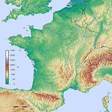
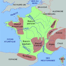
The geography of France consists of a terrain that is mostly flat plains or gently rolling hills in the north and the west and mountainous in the south (including the Massif Central and the Pyrenees) and the east (the country's highest points being in the Alps).
[1] Irrigated land: 26,420 km2 (2007) Total renewable water resources: 211 km3 (2011) Freshwater withdrawal (domestic/industrial/agricultural): 31.62 km3/yr (19%/71%/10%) (512.1 m3/yr per capita) (2009) Coal, iron ore, bauxite, zinc, uranium, antimony, arsenic, potash, feldspar, fluorspar, gypsum, timber, fish, gold, clay, petroleum, silver Flooding, Hailstorms, avalanches, midwinter windstorms, drought, forest fires in the south near the Mediterranean The region that now comprises France consisted of open grassland during the Pleistocene Ice Age.
In prehistoric times, France was home to large predatory animals such as wolves and brown bears, as well as herbivores such as elk.
Smaller animals include martens, wild pigs, foxes, weasels, bats, rodents, rabbits, and assorted birds.
By the 15th century, France had largely been denuded of its forests and was forced to rely on Scandinavia and their North American colonies for lumber.