Geography of Germany
It shares borders with nine countries: Denmark in the north, Poland and the Czech Republic in the east, Switzerland (its only non-EU neighbor) and Austria in the south, France in the southwest and Belgium, Luxembourg and the Netherlands in the west.
Germany is in Central Europe, bordering Denmark in the north, Poland and the Czech Republic in the east, Austria and Switzerland in the south, France and Luxembourg in the south-west, and Belgium and the Netherlands in the north-west.
[4] The northern third of the country lies in the North European Plain, with flat terrain crossed by northward-flowing watercourses (Elbe, Ems, Weser, Oder).
Moving south, central Germany features rough and somewhat patternless hilly and mountainous countryside, some of it formed by ancient volcanic activity.
The central uplands continue east and north as far as the Saale and merge with the Ore Mountains on the border with the Czech Republic.
South of Berlin, the east-central part of the country is more like the low northern areas, with sandy soil and river wetlands such as the Spreewald region.
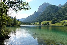
Southern Germany's landforms are defined by various linear hill and mountain ranges like the two adjacent ranges of the Swabian and Franconian Alb (reaching approximately from the source of the Danube in the southwest of Baden-Württemberg, south of Stuttgart, across Swabia into Central Franconia and to the valley of the river Main) and the Bavarian Forest along the border between Bavaria and the Czech Republic.
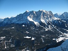
The Alps on the southern border are the highest mountains, but relatively little Alpine terrain lies within Germany (in southeastern Swabia and Upper Bavaria) compared to Switzerland and Austria.
This is caused by some areas being further away from the Atlantic Ocean's Gulf Stream, known for having a warm current for its latitude, in addition to being closer to Russia's and Siberia's extremely cold winter winds.
The coldest area (except for mountain peaks) is found in the southeastern parts of eastern Germany around Dresden and Görlitz up to Berlin.
The north and centre of Germany lies fully in the temperate climatic zone in which humid westerly winds predominate.
[6][7] The recorded extremes are a maximum of 41.2 °C (106.2 °F) (July 2019, Duisburg-Bearl & Tönisvorst),[citation needed] and a minimum of −37.8 °C (−36.0 °F) (February 1929, in Pfaffenhofen an der Ilm).
The border with Switzerland includes the German exclave village of Büsingen am Hochrhein which is separated from the rest of Germany by a strip of Swiss territory 680 metres wide at its narrowest point.
[27] More than 400 registered zoos and animal parks operate in Germany, which is believed to be the largest number in any single country of the world.
For regional administrative purposes five states, namely Baden-Württemberg, Bavaria, Hesse, North Rhine-Westphalia and Saxony, consist of a total of 22 Government Districts (Regierungsbezirke).
[33][34] Germany has a number of large cities; the most populous are: Berlin, Hamburg, Munich, Cologne, Frankfurt, and Stuttgart.
The largest conurbation is the Rhine-Ruhr region (12 million), including Düsseldorf (the capital of North Rhine-Westphalia), Cologne, Essen, Dortmund, Duisburg, and Bochum.