Geography of Iceland
Extent (locations outside mainland in parentheses) Area: Maritime claims: Elevation extremes: Natural resources: Iceland consists of eight geographical regions, Capital Region, Southern Peninsula, West, Westfjords, Northwest, Northeast, East and South.
Iceland has lost most of the woodland that previously covered large areas of the country, but an ambitious reforestation program is currently underway.
Today, however, there are only small patches of the original birch forests left, the most prominent being Hallormsstaðaskógur and Vaglaskógur.
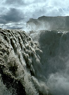
The island's terrain is mostly plateau interspersed with mountain peaks, icefields and a coast deeply indented by bays and fjords.
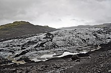
The Highlands make up about half of Iceland's land area, which is of recent volcanic origin and consists of a mountainous lava desert (highest elevation 2,110 m (6,923 ft) above sea level) and other wastelands.
The area also contains mountain ranges and Iceland's highest peak, Hvannadalshnjúkur, as well as the Vestmannaeyjar (Westman Islands) archipelago.
This geographic feature is prominent at the Þingvellir National Park, where the promontory creates an extraordinary natural amphitheatre.
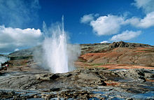
This location means that the island is highly geologically active with earthquakes and volcanoes, notably Hekla, Eldgjá, Herðubreið and Eldfell.
[11] To demonstrate the geothermal activity, the Icelandic Meteorological Office said that during a single week in February 2021, around 17,000 earthquakes have hit the southwestern region of Reykjanes.
With the widespread availability of geothermal power, and the harnessing of many rivers and waterfalls for hydroelectricity, most residents have access to inexpensive hot water, heating, and electricity.
Iceland, however, has a variety of volcanic types (composite and fissure), many producing more evolved lavas such as rhyolite and andesite.
[13] Party to: Signed, but not ratified: This article incorporates public domain material from The World Factbook.