Geography of Italy
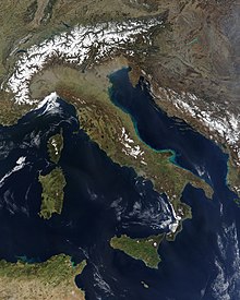
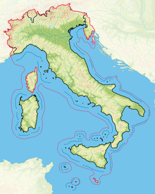
Italy, whose territory largely coincides with the homonymous geographical region,[1] is located in southern Europe and comprises the long, boot-shaped Italian Peninsula crossed by the Apennines, the southern side of Alps, the large plain of the Po Valley and some islands including Sicily and Sardinia.
The municipalities at the ends of Italy are: Although the Istituto Geografico Militare of Florence has repeatedly declared that it is impossible to uniquely determine the center of a non-geometric shape such as that of Italy,[11] there are several locations that, depending on the measurement criteria adopted, compete for the primacy of the geographical centre of Italy: [15][Note 1] The Italian geographical region,[2] in its traditional and most widely accepted extent, has an area of approximately 324,000 square kilometres (125,000 sq mi),[2] which is greater than the area of the entire Italian Republic (301,230 square kilometres or 116,310 square miles).
Continental Italy defined as the southern side of the Alps, the Po Valley, Liguria and the portion of the Apennines bounded by the conventional line that connects La Spezia to Rimini.
Peninsular Italy refers to the entire southern part of the aforementioned line, up to Punta Melito in Calabria (which is the southernmost point of the peninsula) and Santa Maria di Leuca in Apulia.
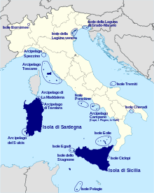
Insular Italy is made up of Sardinia, Sicily and numerous smaller islands, scattered or grouped into archipelagos in the seas that bathe the coasts of the peninsula.
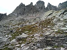
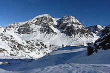
The five largest islands belonging to the Italian state are, in order of size: Other islands belonging to Italy are grouped into the following archipelagos: Almost 40% of the Italian territory is mountainous,[17] with the Alps as the northern boundary and the Apennine Mountains forming the backbone of the peninsula and extending for 1,350 km (840 mi).
[17] The Alpine mountain range is linked with the Apennines with the Colle di Cadibona pass in the Ligurian Alps.
The Alps contain the highest peak in the European Union, Mont Blanc, at 4,810 meters (15,780 ft) above sea level, located between the Aosta Valley and France.
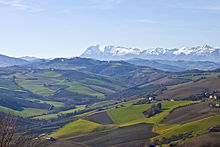
They are mainly located in the central-southern part of the peninsula,[21] along the sides of the Apennine ridge, but also in the pre-Alpine area, close to the Alps.
In between the two lies a large plain in the valley of the Po, the largest river in Italy, which flows 652 km (405 mi) eastward from the Cottian Alps to the Adriatic.
In the peninsular part and in the islands there are only small plains often located along the coasts and at the mouth of the major rivers, near which they formed:[22] this is the case, for example, of the Tavoliere delle Puglie, of the Campidano in Sardinia or the Maremma in Tuscany.
[22] The Italian plains have different origins: Italy is surrounded, except to the north, by the sea, and its territory has a rich reserve of inland waters (rivers and lakes).
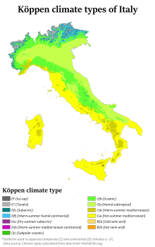
The southern regions, however, are drier than the northern ones, due to the scarcity of rains and the absence of glaciers that can feed the rivers.
Italian rivers are shorter than those of other European regions due to the Apennines that run along the entire length of the peninsula, dividing the waters into two opposite sides.
The fundamental watershed follows the ridge of the Alps and the Apennines and defines five main slopes, corresponding to the seas into which the rivers flow: the Adriatic, Ionic, Tyrrhenian, Ligurian and Mediterranean sides.
The second longest Italian river is the Adige (410 km or 250 mi), which originates near Lake Resia and flows into the Adriatic Sea, after having made a north–south route, near Chioggia.
Most of Italy's rivers drain either into the Adriatic Sea (such as Po, Piave, Adige, Brenta, Tagliamento, Reno) or into the Tyrrhenian (like Arno, Tiber and Volturno), though the waters from some border municipalities drain into the Black Sea through the basin of the Drava (Innichen and Sexten in Trentino-Alto Adige/Südtirol, Tarvisio in Friuli-Venezia-Giulia) or the Inn (Livigno in Lombardy), both tributaries of the Danube, and the waters from the Lago di Lei in Lombardy drain into the North Sea through the basin of Rhine.
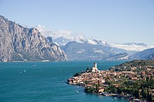
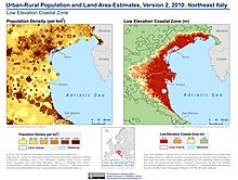
The Adriatic Sea bathes the eastern coasts of the peninsula, from Friuli-Venezia Giulia to the Cape of Santa Maria di Leuca, Apulia.
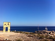
[28] Italy has a coastline of approximately 7,900 km (4,900 mi),[29][30] with a great variety of shapes that depends both on the nature of the mainland and on the action of the sea.
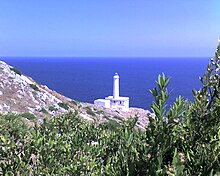
Only in the Trieste area, in correspondence with the Gargano, the Conero and the lower eastern Salento (between Otranto and Santa Maria di Leuca) do rocky sections follow one another.
The Tyrrhenian coasts are very articulated, with rocky stretches alternating with sandy beaches, with numerous gulfs and headlands.
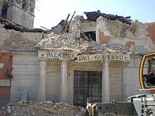
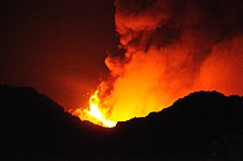
[26] The underground thrusts that millions of years ago gave rise to the reliefs of Italy still continue: the earthquakes and the eruptive activity of volcanoes testify to this.