Apennine Mountains
The Apennines[2] or Apennine Mountains (/ˈæpənaɪn/ AP-ə-nyne; Ancient Greek: Ἀπέννινα ὄρη or Ἀπέννινον ὄρος;[3] Latin: Appenninus or Apenninus Mons – a singular with plural meaning;[4] Italian: Appennini [appenˈniːni])[note 1] are a mountain range consisting of parallel smaller chains extending c. 1,200 km (750 mi) the length of peninsular Italy.
These mountains are one of the last refuges of the big European predators such as the Italian wolf and the Marsican brown bear, now extinct in the rest of Central Europe.
The Apennine culture is a technology complex in central and southern Italy from the Italian Middle Bronze Age (15th–14th centuries BC).
Apennine pottery is a burnished ware incised with spirals, meanders and geometrical zones, filled with dots or transverse dashes.
[14] The people of the Apennine culture were alpine cattle herdsmen grazing their animals over the meadows and groves of mountainous central Italy.
The Grand Italian Trail begins in Trieste and after winding through the Alpine arc traverses the entire Apennine system, Sicily and Sardinia.
The upper Bormida can be reached by a number of roads proceeding inland at a right angle to the coast southwest of Savona, the chief one being the Autostrada Torino-Savona.
Topographically only the valley of the River Serchio, which running parallel to the coast turns and exits into the Tyrrhenian Sea north of Pisa, separates the Apuan Alps from the Apennines; geologically the rock is of a slightly different composition, marble.
As the Tuscan Apennines divide the peninsula between the Po Valley and the plains and hills of Tuscany and Lazio, transportation over them has been used to achieve political and economic unity.
The montane distance between Florence in Tuscany and Bologna in Emilia-Romagna is shorter, but exploitation of it required the conquest of more rugged terrain, which was not feasible for the ancients.
[note 2] Automobile traffic is carried by the Autostrada del Sole, Route A1, which goes through numerous shorter tunnels, bypassing an old road, originally Roman, through Futa Pass.
In December 2015, a new Route A1 called Variante di Valico was opened after many years of construction consisting of major tunnels (the longest being the new 8.6-kilometre (5.3-mile) 'Tunel Base') and new overpasses, shortening the traveling time between Florence and Bologna by road.
The southern limit of the Tuscan–Romagnol Apennines is the Bocca Serriola Pass in northern Umbria, which links Fano and Città di Castello.
The Tiber River at Rome flows from Monte Fumaiolo in the Tuscan-Romagnol Apennine from northeast to southwest, projecting into the Tyrrhenian Sea at right angles to the shore.
On the east there is at first a succession of small rivers which flow into the Adriatic, from which the highest points of the chain are some 20 km distant, such as the Tronto, Tordino, Vomano and others.
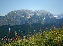
In the southern Apennines, to the south of the Sangro valley, the three parallel chains are broken up into smaller groups; among them may be named the Matese, the highest point of which is the Monte Miletto 2,050 metres (6,725 ft).
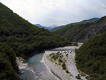
The chief rivers on the south-west are the Liri or Garigliano with its tributary the Sacco, the Volturno, Sebeto, Sarno, on the north the Trigno, Biferno and Fortore.
At the narrowest point the plain of Sibari, through which the rivers Coscile and Crati flow to the sea, occurs on the east coast, extending halfway across the peninsula.
[21] The first group extends as far as the isthmus formed by the gulfs of South Eufemia and Squillace; it is known as the Sila, and the highest point reached is 1,930 metres (6,330 ft) (the Botte Donato).
The second group extends to the south end of the Italian Peninsula, culminating in the Aspromonte (1,960 metres (6,420 ft)) to the east of Reggio di Calabria.
[33] In Italy the transhumance took place mainly starting from the Abruzzi Apennines, moving both towards the Tuscan and Lazio Maremma and above all towards the Tavoliere delle Puglie.
[34] The Apennines are to some extent covered with forests, though these were probably more extensive in classical times (Pliny mentions especially pine, oak and beech woods, Hist.
In the forests Italian wolves were frequent, and still are found, the flocks being protected against them by large sheep-dogs; Marsican brown bears, however, which were known in Roman times, have almost entirely disappeared.
An inscription found near the Furlo pass was set up in AD 246 by an evocatus Augusti (a member of a picked corps) on special police duty with a detachment of twenty men from the Ravenna fleet.
Important rivers originate from the Apennines are the Panaro, the Secchia, the Reno, the Marecchia, the Rubicon, the Metauro, the Arno, the Tiber, the Savio, the Nera, the Velino, the Tronto, the Aterno-Pescara, the Aniene, the Liri, the Sangro and the Volturno.
According to the older theories (originating from the 1930s to 1970s) of Dutch geologists, including Van Bemmelen, compression and extension can and should occur simultaneously at different depths in a mountain belt.
More recent work in geotectonics and geodynamics of the same school of geoscientists (Utrecht and Amsterdam University) by Vlaar, Wortel, and Cloetingh, and their disciples, extended these concepts even further into a temporal realm.
The gradual subsidence of the Po Valley (including that of Venice) and the folding of the mountains of eastern Italy have been investigated using seismic wave analysis of the "Apennine Subduction System.
The west side of Italy is given to a fault-block system, where the crust – extended by the lengthening mantle below – thinned, broke along roughly parallel fault lines, and the blocks alternatively sank into grabens or were raised by isostasy into horsts.
The terrain of the Apennines (as well as that of the Alps) is to a large degree unstable due to various types of landslides, including falls and slides of rocks and debris, flows of earth and mud, and sink holes.