Geography of Kent
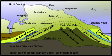
These ridges are the remains of the Wealden dome, a denuded anticline across Kent, Surrey and Sussex, which was the result of uplifting caused by the Alpine movements between 10-20 million years ago.
[5] Dartford, Gravesend, The Medway Towns, Sittingbourne, Faversham, Canterbury, Deal and Dover are built on chalk.
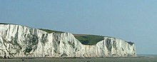
[6] The chalk displays all its characteristic features such as steep sided dry valleys, and sunken roads.
[4] The Hastings Beds, which are resistant to weathering, leading to outcrops, such as High Rocks Tunbridge Wells, and sterile soil only suited to heathland and forests of Scots Pine.
The Fairlight Clays form the upper part of the Ashdown Formation; grey and varigated shales.
[7] Much of the area remains today densely wooded; where there are also heavy clays the tracks through are nearly impassable for much of the year.
The Wealden dome is a Mesozoic structure lying on a Palaeozoic foundation, which usually creates the right conditions for coal formation.
Here it breaks through the North Downs at Rochester before joining the River Thames as its final tributary near Sheerness.
[10] The river is tidal as far as Allington lock, but in earlier times cargo-carrying vessels reached as far upstream as Tonbridge.
The wide range of habitats in the area gives the county a rich variety of Kent's plant and animal species.