North Downs
The North Downs are a ridge of chalk hills in south east England that stretch from Farnham in Surrey to the White Cliffs of Dover in Kent.
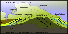
The narrow spine of the Hog's Back between Farnham and Guildford forms the western extremity of the North Downs, whilst the cliffs between Folkestone and Deal terminate the ridge in the east.
Its southern boundary is defined by the low-lying Vale of Holmesdale at the foot of the escarpment, in which the underlying stratum is primarily gault clay.
The ridge of the North Downs is intersected by the valleys of a series of rivers: the Wey, Mole, Darent, Medway and Stour.
Leith Hill (the highest point in Surrey) is sometimes incorrectly referred to as part of the North Downs, but it is located on the parallel Greensand Ridge[7] and does not consist of chalk.
[8] The Downland of the North Downs consists of distinct lithostratigraphic units (the types of strata, the names of which are always capitalised): Following the Cretaceous, the sea covering the south of England began to retreat and the land was pushed higher.
It is porous, absorbing up to 20% of its dry weight in water,[15] and is therefore highly susceptible to weathering by freeze-thaw action, which may occur over repeated annual or diurnal cycles.
This frost weathering produces a mix of rubble and viscous mud, which may be washed downhill, further eroding the landscape (a process known as solifluction).
The alkaline soils are thin and nutrient poor, which prevents deeper-rooted lush grasses (with a high water demand) from dominating.
[1] Owing to the close proximity of the North Downs to the European continent, the warm climate and the south-facing escarpment, several plant species survive on the chalk grassland which are scarce or not found elsewhere in the British Isles.
Other scarce plant species such as early gentian, dwarf milkwort and bedstraw broomrape also occur on chalk grassland in the North Downs.
Notable butterfly species include Adonis blue and silver-spotted skipper, which may be found on warm, sheltered, south-facing slopes.
On the summit of the cliffs between Deal and Folkestone the early spider orchid occurs in large numbers, as well as the rare oxtongue broomrape.
[22] Although its spread is often considered undesirable, scrub provides valuable habitat for a range of invertebrates, including the Roman snail, rufous grasshopper and the dark green fritillary.
[21] There is considerable evidence of Mesolithic activity in the Surrey Downs through the discovery of pit-dwellings at Weston Woods near Albury and the quantity of discarded tools, microliths and other implements discovered.
[23] There is substantial evidence of Neolithic activity within the North Downs, notably the long barrows concentrated in the Medway and Stour valleys.
The woodland that remains today is largely located where deforestation has been inhibited by steep slopes or by the layer of clay with flints, which is difficult to plough.
Much chalk grassland and ancient woodland on the Downs is open-access, and there are also many historic sites such as Kit's Coty House (near Maidstone) and Dover Castle.